Forestation is one of the main strategies recommended by the scientific community for climate change mitigation.
Forestation is one of the main strategies recommended by the scientific community for climate change mitigation. But, would a European continent completely covered in forests be any cooler than one without forests? Asking these kinds of questions is fundamental to developing an understanding of the real effects of solutions that have been recommended by the scientific community for the reduction of greenhouse gas concentrations in the atmosphere, so that decision-makers are prepared to adequately manage the potential consequences that may arise from land use planning policies that include variations in the use of land for climate protection. What is more, the answer to this particular question may not be so obvious.
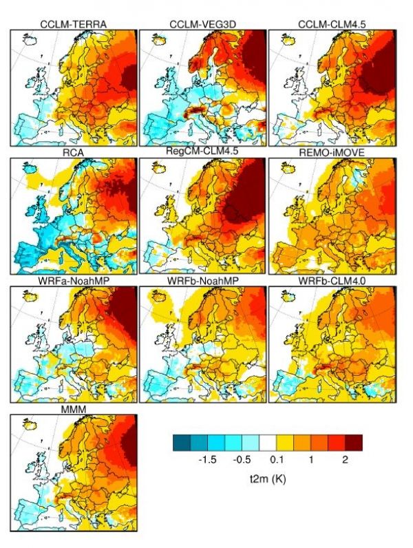
The paper Biogeophysical impacts of forestation in Europe: first results from the LUCAS (Land Use and Climate Across Scales) regional climate model intercomparison, describes the preliminary phase of the CORDEX FPX – LUCAS (Land Use and Climate Across Scales) project. The project aims to investigate the regional and local effects of land use changes on different climate dimensions, from seasonal temperature variability to extreme events (such as heat waves and drought), in the short and long term. Thanks to multi-model experiments, scientists will be able to anticipate the intended and unintended consequences of land use planning policies on regional climates, even with high levels of precision that will reach up to 1-3 km in accuracy.
The newly released study, realized with the contribution of the CMCC Foundation – Euro-Mediterranean Center on Climate Change among other members of EUROCORDEX – key player in the context of European scientific research on regional climate models – compares two ideal scenarios. The two scenarios assume an absence of urban areas and man-made constructions and in turn cover all land in Europe (excluding parts that are already occupied by rivers, lakes, seas, glaciers and deserts) with either trees (“forest” scenario) or grassland (“grass” scenario). Comparing these two idealized scenarios has enabled scientists to study how atmospheric variables, such as temperatures and energy balance, respond in two “extreme” cases of land use. An intermediate step towards the definition of more realistic scenarios in the subsequent phases of the project.
Read more at Euro-Mediterranean Center on Climate Change
Image: Seasonally averaged 2m temperature (scenario “forest” minus scenario “grass”) for winter (December-January-February) – The image highlights the agreement of the nine models on a winter warming effect over the northeast of Europe in the “forest” case scenario. CREDIT: Euro-Mediterranean Center on Climate Change


