Strong storms bringing high winds and torrential rain began to sweep into Rio Grande do Sul, Brazil’s southernmost state, on April 27, 2024.
Strong storms bringing high winds and torrential rain began to sweep into Rio Grande do Sul, Brazil’s southernmost state, on April 27, 2024. In some areas, more than 300 millimeters (12 inches) of rain fell in less than a week, overtopping river banks and leading to widespread, destructive flooding.
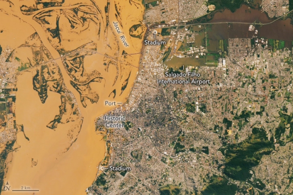
The OLI (Operational Land Imager) on Landsat 8 captured an image (above) of Porto Alegre’s flooded downtown area on May 8, 2024. Floodwater inundated the historic district, caused the international airport to close, swept through major stadiums, and left several highways impassable.
The MODIS (Moderate Resolution Imaging Spectroradiometer) on NASA’s Terra and Aqua satellites acquired these images (below) on May 6 and April 20, during and before the flooding. Water overtopped the banks of the Jacuí, Cai, and Sinos rivers, inundating parts of Porto Alegre, the state’s capital city. Floodwater also spilled into several other cities, towns, and farmland upriver. Runoff, stained brown with suspended sediment, is visible flowing into the Patos Lagoon, south of Porto Alegre.
Read more at: NASA Earth Observatory
Photo Credit: Wanmei Liang


