
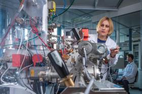
With high-pressure experiments at DESY's X-ray light source PETRA III and other facilities, a research team around Leonid Dubrovinsky from the University of Bayreuth has solved a long standing riddle in the analysis of meteorites from Moon and Mars. The study, published in the journal Nature Communications, can explain why different versions of silica can coexist in meteorites, although they normally require vastly different conditions to form. The results also mean that previous assessments of conditions at which meteorites have been formed have to be carefully re-considered.
>> Read the Full Article

Researchers at Umeå University have developed a model that uses seasonal weather data from satellite images to accurately predict outbreak of malaria with a one-month lead time. With a so-called GAMBOOST model, a host of weather information gathered from satellite images can be used as a cost-effective disease forecasting model, allowing health officials to get ahead of the malaria infection curve by allocating resources and mobilizing public health responses. The model was recently described in the journal Scientific Reports, a Nature Research publication.
>> Read the Full Article
When a soil dries out, this has a negative impact on the activity of soil bacteria. Using an innovative combination of state-of-the-art analysis and imaging techniques, researchers at UFZ have now discovered that fungi increase the activity of bacteria in dry and nutrient-poor habitats by supplying them with water and nutrients. The ability of fungi to regulate drought stress in soil and thus sustain ecosystem functions is an important insight in the context of climate change.
>> Read the Full Article
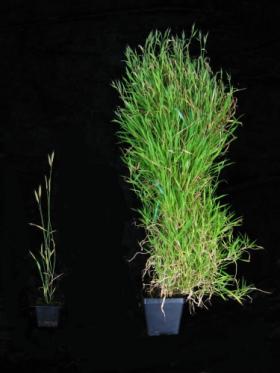
Winter is no time to flower, which is why so many plants have evolved the ability to wait for the snow to melt before investing precious resources in blooms.
Waking up to flower as the warmer, longer days of spring arrive — and the risk of a damaging frost recedes — requires a process called vernalization, in which flowering is blocked until the plant senses a sufficient cold spell. Researchers at the University of Wisconsin–Madison have identified a gene that keeps grasses from entering their flowering cycle until the season is right, a discovery that may help plant breeders and engineers get more from food and energy crops.
>> Read the Full Article

Noise from motorboats is making fish become bad parents, and reducing the chance of their young surviving, research led by marine experts at the University of Exeter has shown.
The sound of motorboat engines disturbed coral reef fish so acutely it changed the behaviour of parents, and stopped male fish properly guarding their young, feeding and interacting with their offspring.
>> Read the Full Article

A new advance on a method developed by MIT researchers could enable continuous, high-precision monitoring of materials exposed to a high-radiation environment. The method may allow these materials to remain in place much longer, eliminating the need for preventive replacement. It could also speed up the search for new, improved materials for these harsh environments.
The new findings appear in the journal Applied Physics Letters, in a paper by graduate student Cody Dennett and assistant professor of nuclear science and engineering Michael Short. This study builds on the team’s earlier work that described the benchmarking of the method, called transient grating spectroscopy (TGS), for nuclear materials. The new research shows that the technique can indeed perform with the high degree of sensitivity and time-resolution that the earlier calculations and tests had suggested should be possible for detecting tiny imperfections.
>> Read the Full Article

Ophir Klein is growing teeth, which is just slightly less odd than what Jeffrey Bush is growing – tissues that make up the face. Jason Pomerantz is growing muscle; Sarah Knox is growing salivary glands; and Edward Hsiao is printing 3-D bone using a machine that looks about as complex as a clock radio.
Together, these members of the UC San Francisco faculty are cultivating organs of the craniofacial complex – the skull and face – which too often go terribly wrong during fetal development. Deformities of these bones or soft tissues, the most common of birth defects, can cut life short by blocking the airway or circulation. Or they can disfigure a face so profoundly that a child struggles to see, hear, or talk. Perhaps most painful of all, such deformities render children physically other, potentially leading to a lifetime of corrective surgeries and social isolation.
>> Read the Full Article
At least 100,000 military veterans who served in the 1990-1991 Gulf War were exposed to chemical weapons, released into the air after the United States bombed an ammunition depot in Khamisiyah, Iraq. Today, many are still suffering from Gulf War Illness, a mysterious, multi-symptom disease that experts believe is linked to organophosphate nerve agents sarin and cyclosarin.
>> Read the Full Article


