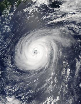
NASA’s Aqua satellite is keeping track of Typhoon Noru as it continues its slow trek through the Northwestern Pacific Ocean.
On August 2, 2017 at 12:05 a.m. EDT (0405 UTC) the Moderate Resolution Imaging Spectroradiometer or MODIS instrument that flies aboard NASA’s Aqua satellite captured a visible image of Typhoon Noru. The MODIS image shows a symmetric band of thunderstorms completely surrounding a well-defined eye feature.
>> Read the Full Article
Scientists at the University of York have shown that using historical wildlife data provides a more accurate measure of how vulnerable certain species might be to extinction from climate change.
Some of the methods used to predict at risk species are trend-based – an indicator of what happens gradually over time – while others are trait based, which uses signs of climate change in the current environment.
>> Read the Full Article
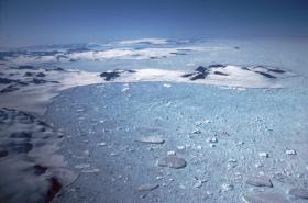
The largest remaining ice shelf on the Antarctic Peninsula lost 10% of its area when an iceberg four times the size of London broke free earlier this month.
Since the 12 July 2017 breakaway Dr Anna Hogg, from the University of Leeds, and Dr Hilmar Gudmundsson, from the British Antarctic Survey (BAS), have continued to track the iceberg – known as A68 – using the European Space Agency (ESA) and European Commission’s Copernicus Sentinel-1 satellite.
>> Read the Full Article
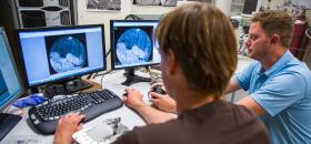
University of Calgary geoscientists have developed new technology that measures, at an extremely fine scale, the interaction between water and other fluids and rock from an unconventional oil reservoir.
Faculty of Science researchers used their micro-injection system coupled with live imaging to precisely measure fluid-rock interaction, called “wettability,” at the microscopic, or micro-scale, for the first time.
>> Read the Full Article

A new study links rising temperatures and subsequent crop failures to more than 59,000 suicides in India over the past 30 years.
The study, published in the Proceedings of the National Academy of Sciences, analyzed 47 years of suicide records from India’s National Crime Records Bureau, as well as data on temperature, climate, and crop yields. It found that on days above 68 degrees Fahrenheit, a 1.8 degrees rise in temperature caused an average of 70 suicides. This correlation was found only during growing seasons, when higher temperatures can damage crop yields and deal devastating blows to the one-third of Indian farmers who live below the international poverty line.
>> Read the Full Article
Like tourist season, wildfire season is also in full swing in British Columbia. Whereas tourists are welcomed to the Canadian province, wildfires are not. In British Columbia alone there are close to 500 wildfires active to date. Most of these wildfires are located in three general areas--in the Caribou Fire Centre located in the Frasier Plateau directly north of Vancouver, in the Kamloops Fire Centre in the Thomas Plateau, which is east of Whistler, and the Southeast Fire Centre which is east of Kamloops. All current fires of note can be viewed on this interactive map: http://governmentofbc.maps.arcgis.com/apps/webappviewer/index.html?id=a1e7b1ecb1514974a9ca00bdbfffa3b1
Wildfires in British Columbia are common at this time of year due to rising temperatures, however, this year is the third worst year in the region for forest fires. To date 840 fires have broken out since April 1 of this year. Although it started slow, 2017 is shaping up to be a record breaking fire season if not for numbers of fires, then for the sheer amount of hectares burned. In an area where rainfall is the norm, to have days and weeks without rainfall is unusual and helps to create a hot, dry environment with plenty of underbrush that fires use as fuel.
>> Read the Full Article


