
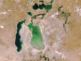
Envisat images highlight the dramatic retreat of the Aral Sea’s shoreline from 2006 to 2009. The Aral Sea was once the world’s fourth-largest inland body of water, but it has been steadily shrinking over the past 50 years since the rivers that fed it were diverted for irrigation projects. By the end of the 1980s, it had split into the Small Aral Sea (north), located in Kazakhstan, and the horse-shoe shaped Large Aral Sea (south), shared by Kazakhstan and Uzbekistan.
Envisat images highlight the dramatic retreat of the Aral Sea’s shoreline from 2006 to 2009. The Aral Sea was once the world’s fourth-largest inland body of water, but it has been steadily shrinking over the past 50 years since the rivers that fed it were diverted for irrigation projects.
By the end of the 1980s, it had split into the Small Aral Sea (north), located in Kazakhstan, and the horse-shoe shaped Large Aral Sea (south), shared by Kazakhstan and Uzbekistan.
!ADVERTISEMENT!
By 2000, the Large Aral Sea had split into two – an eastern and western lobe. As visible in the images, the eastern lobe retreated substantially between 2006 and 2009. It appears to have lost about 80% of its water since the 2006 acquisition, at which time the eastern lobe had a length of about 150 km and a width of about 70 km.
The sea’s entire southern section is expected to dry out completely by 2020, but efforts are underway to save the northern part.
As the Aral Sea evaporated, it left behind a 40 000 sq km zone of dry, white salt terrain now called the Aral Karakum Desert. Each year violent sandstorms pick up at least 150 000 tonnes of salt and sand from the Aral Karakum and transport it across hundreds of km, causing severe health problems for the local population and making regional winters colder and summers hotter.
For more information: http://www.esa.int/esaEO/SEMGVT6CTWF_index_0.html


