
The Arctic still has unmapped and unknown areas. In particular, there is the continental shelf that extends out from the American and Canadian northern lands. Who controls it? Who has the right to drill for example which then leads into the complicated morass of environmental rules and controls. American and Canadian scientists are setting sail this summer to map the Arctic seafloor and gather data to help define the outer limits of the continental shelf. Each coastal nation may exercise sovereign rights over the natural resources of their continental shelf, which includes the seabed and subsoil. These rights include control over minerals, petroleum, and sedentary organisms such as clams, crabs and coral.
The Arctic still has unmapped and unknown areas. In particular, there is the continental shelf that extends out from the American and Canadian northern lands. Who controls it? Who has the right to drill for example which then leads into the complicated morass of environmental rules and controls. American and Canadian scientists are setting sail this summer to map the Arctic seafloor and gather data to help define the outer limits of the continental shelf. Each coastal nation may exercise sovereign rights over the natural resources of their continental shelf, which includes the seabed and subsoil. These rights include control over minerals, petroleum, and sedentary organisms such as clams, crabs and coral.
!ADVERTISEMENT!Under international law, specifically the United Nations Convention on the Law of the Sea, every coastal nation automatically has a continental shelf out to 200 nautical miles or to a maritime boundary. The Convention also states that a nation is entitled to continental shelf beyond 200 nautical miles if certain criteria are met, an area that is referred to as the extended continental shelf.
Just off shore is the continental shelf which is part of the tectonic plate that is a continent. From the shelf is a slope that goes to the abyssal ocean bottom.
These shelf criteria include the continental margin comprising the submerged portion adjacent to the coastal State. It does not include the deep ocean floor with its oceanic ridges. What has to happen is that the edge of the continental shelf has to be measured based on the geology and sediments present.
Where this has most impacts is in the Arctic and Atlantic coasts where the shelf extends a bit. For example just off Alaska are a series of islands that are portion of this shelf that are not submerged. In between the islands and Alaska is part of this extended shelf.
In other parts of the world such as the East China Sea, the North Sea and the borders of Brunei and Malaysia, there is and has long been considerable dispute of who owns what rights to what part of this shelf. Establishing clear rights will reduce not only the threat of war but the problems of interfering operations infringing on the environmental controls of each others operations.
The U.S. Geological Survey is the lead science agency for the United States in the 2010 mission.
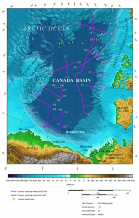
'In this expedition, Canada and the U.S. are working together to delineate the extended continental shelf in the Arctic to better determine where the Convention’s criteria can be met," said USGS scientist Brian Edwards, chief scientist on the U.S. Coast Guard Cutter Healy.The Healy will sail August 2 – September 6, 2010, meeting up with the Canadian Coast Guard Ship Louis S. St-Laurent at sea.
The ships will alternately break through the Arctic sea ice for each other. The Healy will map the shape of the seafloor using a multibeam echo sounder, and the Louis S. St-Laurent will collect multi-channel seismic reflection and refraction data to determine sediment thickness.
This is the third year the United States and Canada have collaborated in extended continental shelf data collection in the Arctic. "The Arctic Ocean is an area of great interest for science, resource conservation, and possible economic development,†said USGS scientist Deborah Hutchinson. “Because there is an area with considerable overlap between the U.S. and Canadian extended continental shelves, it makes sense to share data sets and work together in the remote and challenging environments of the Arctic Ocean."
For further information: http://www.usgs.gov/newsroom/article.asp?ID=2556&from=rss&utm_source=feedburner&utm_medium=feed&utm_campaign=Feed%3A+UsgsNewsroom+%28USGS+Newsroom%29&utm_content=Google+Reader


