
Nuclear fallout in farmland in eastern Japan is worse than expected. Now officials have a map of exactly where they should concentrate regulatory and clean-up efforts. In July the Japanese government expanded its Fukushima Evacuation Zone and banned shipments of beef that consumed radioactive hay from the area. But until now, officials have had to rely almost exclusively on sporadic soil samples to make such decisions.
Nuclear fallout in farmland in eastern Japan is worse than expected. Now officials have a map of exactly where they should concentrate regulatory and clean-up efforts.
!ADVERTISEMENT!
In July the Japanese government expanded its Fukushima Evacuation Zone and banned shipments of beef that consumed radioactive hay from the area.
But until now, officials have had to rely almost exclusively on sporadic soil samples to make such decisions.
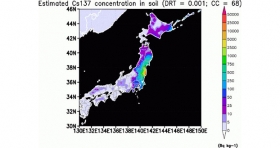
A study released Monday in the Proceedings of the National Academy of Sciences (PNAS) modeled the spread of cesium-137, a radionuclide that can persist in soils for 30 years, across much of the country. The new map defines the highest risk areas beyond Fukushima and neighboring prefectures, which were already known from soil samples to far exceed contamination limits set by Japanese law.
Areas hardest hit (red in the map) are nearest the Fukushima Daiichi Nuclear Power Plant, which experienced reactor meltdowns following the March 11, 2011, earthquake and tsunami.
Because cesium-137 is bound to dust and water particles in the air, it travels with the weather. The new model, which infused actual cesium-137 measurements from observatories across the country into meteorological data for the month following the accident, reveals that the areas of highest concern are northern and eastern Japan (green and blue in the map).
Article continues: http://news.discovery.com/earth/japans-radioactive-farmland-111114.html#mkcpgn=rssnws1
Image credit: Teppei J. Yasunari and co-authors


