
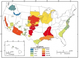
The High Plains (also known as Ogallala) aquifer underlies more than 170,000 square miles of the United States. Aquifers are water storage areas that are made up of bodies of permeable rock that contain and transmit groundwater. The High Plains aquifer serves as the principal source of water for irrigation and drinking in the Great Plains, serving over two million people. However, substantial pumping of the aquifer for irrigation since the 1940s has resulted in large water-table declines. Depleting aquifers of groundwater can lead to serious consequences as pumping water out of the ground faster than it can be replenished can permanently dry up wells, reduce water in lakes and streams, and deteriorate water quality.
The High Plains (also known as Ogallala) aquifer underlies more than 170,000 square miles of the United States. Aquifers are water storage areas that are made up of bodies of permeable rock that contain and transmit groundwater. The High Plains aquifer serves as the principal source of water for irrigation and drinking in the Great Plains, serving over two million people. However, substantial pumping of the aquifer for irrigation since the 1940s has resulted in large water-table declines.
!ADVERTISEMENT!
Depleting aquifers of groundwater can lead to serious consequences as pumping water out of the ground faster than it can be replenished can permanently dry up wells, reduce water in lakes and streams, and deteriorate water quality.
Yet, since 2000, depletion of the High Plains aquifer appears to be continuing at a high rate, with no plans of slowing down. The depletion during the last 8 years of record (2001–2008, inclusive) is about 32 percent of the cumulative depletion in this aquifer during the entire 20th century.
The High Plains aquifer depletion is just one example in a new U.S. Geological Survey study that reveals most of the Nation's aquifers are being depleted at an accelerating rate.
The study, Groundwater Depletion in the United States (1900-2008) comprehensively evaluates long-term depletion volumes in 40 separate US aquifers.
"Groundwater is one of the Nation's most important natural resources. It provides drinking water in both rural and urban communities. It supports irrigation and industry, sustains the flow of streams and rivers, and maintains ecosystems," said Suzette Kimball, acting USGS Director. "Because groundwater systems typically respond slowly to human actions, a long-term perspective is vital to manage this valuable resource in sustainable ways."
The study reports that from 1900 to 2008, the Nation's aquifers, decreased by more than twice the volume of water found in Lake Erie. Also, groundwater depletion in the U.S. in the years 2000-2008 can explain more than 2 percent of the observed global sea-level rise during that period.
While the rate of groundwater depletion across the country has increased markedly since about 1950, the maximum rates have occurred during the most recent period of the study (2000–2008), when the depletion rate averaged almost 25 cubic kilometers per year. For comparison, 9.2 cubic kilometers per year is the historical average calculated over the 1900–2008 timespan of the study.
See more at the USGS Newsroom.
Read the study and see the aquifer depletion graphic via Groundwater Depletion in the United States (1900-2008).


