When a 7.9-magnitude earthquake struck central China's Sichuan province in 2008, seismic waves rippled through the region, toppling apartment houses in the city of Chengdu and swaying office buildings 1,000 miles away in Shanghai.
Though destructive, earthquakes provide benefit in one respect: they help researchers learn about the structure of the Earth, which in turn could lead to more accurate predictions of damage from future quakes and volcanic activity. By eavesdropping on the seismic vibrations of quakes as they rumble through the Earth, researchers can detect the existence of structures such as mineral deposits, subterranean lakes, and upwellings of magma. Thanks to a growing earthquake detection network and superfast computers, geoscientists are now able to explore the Earth's interior, a region that has been more inaccessible than the deepest ocean or the farthest planet in our solar system.
Princeton geosciences professor Jeroen Tromp and his team have embarked on an ambitious project to use earthquakes to map the Earth's entire mantle, the semisolid rock that stretches to a depth of 1,800 miles, about halfway down to the planet's center and about 300 times deeper than humans have drilled. For the task, his team will use one of the world's fastest supercomputers, Titan, which can perform more than 20 quadrillion calculations per second and is located at the Department of Energy's Oak Ridge National Laboratory in Tennessee.
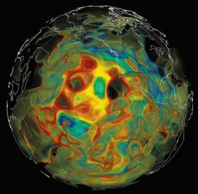
Computer simulations use the speed of seismic waves from earthquakes to reveal the existence of subterranean structures. In this view of the mantle below the Pacific Ocean, slower waves are shown in red and orange while faster waves are shown in green and blue. The faster waves are associated with subduction zones where one tectonic plate sinks underneath another plate. (Image courtesy of Ebru BozdaÄŸ, University of Nice Sophia Antipolis, and David Pugmire, Oak Ridge National Laboratory)
"Seismology is changing at a fundamental level due to advances in computing power," said Tromp, who earned his Ph.D. in geology from Princeton and is Princeton's Blair Professor of Geology, professor of applied and computational mathematics, and associate director of the Princeton Institute for Computational Science and Engineering. "If someone had told me what seismology would look like 20 years from when I graduated from Princeton in 1992, I would have never believed it."
For the project, Tromp will use seismic waves from roughly 3,000 quakes of magnitude 5.5 and greater, recorded at thousands of seismographic stations worldwide and distributed via the National Science Foundation's Incorporated Research Institutions for Seismology. These stations make recordings, or seismograms, that detail the movement produced by seismic waves, which typically travel at speeds of several miles per second and last several minutes.
"The ultimate goal is a 3-D map on a global scale," said Tromp, who expects to have preliminary results at the end of this year. "We are specifically interested in the structure of mantle upwellings and plumes," he said, "but much of it will be investigating the images for unusual features."
Computer simulations use the speed of seismic waves from earthquakes to reveal the existence of subterranean structures. In this view of the mantle below the Pacific Ocean, slower waves are shown in red and orange while faster waves are shown in green and blue. The faster waves are associated with subduction zones where one tectonic plate sinks underneath another plate. (Image courtesy of Ebru BozdaÄŸ, University of Nice Sophia Antipolis, and David Pugmire, Oak Ridge National Laboratory)
Read more at Princeton University.


