
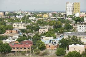
Turning natural landscapes in the Caribbean into urban areas or farmland may increase the risk of people dying from floods and storms, scientists suggest.
In a study published by Scientific Reports last month (8 July), researchers from Anguilla’s health ministry and the Catholic University of Louvain in Belgium investigate which factors make the region more prone to deaths related to these disasters. Out of 20 variables, they found that using a greater proportion of land for agriculture and having a higher percentage of people living in urban areas were consistently linked with deadlier floods and storms.
“As natural landscapes are transformed into agricultural land, the protective effect that they offer to human populations might be seriously reduced.”
“As natural landscapes are transformed into agricultural land, the protective effect that they offer to human populations might be seriously reduced,” says José Rodriguez-Llanes from the Catholic University of Louvain and one of the study authors. The same applies to unplanned urbanisation, he says.
The Caribbean is commonly hit by floods and tropical cyclones. Between 2000 and 2012, 113 such disasters were reported in the 15 countries that make up the Caribbean Community (CARICOM), of which 85 caused deaths, the paper says. This is more than double the number linked to similar events in the previous 20 years, it says.
“We analysed 32 years of floods and storms data from the CARICOM nations along with development indicator data from the World Bank,” Rodriguez-Llanes says.
The analysis provides “early insights not only into the most important determinants of lethality, but those with potentially far-reaching policy implications”, the paper says.
Santo Domigo image via Shutterstock.
Read more at ENN Affiliate, SciDevNet.


