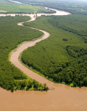
As the Missouri River flows across the Great Plains to where it meets the Mississippi River at St. Louis, it accumulates such a large sediment load that it has earned the nickname “Big Muddy.” A recent University of Illinois study looks at the history of the river, damages and changes from the 2011 flood, and its current post-flood condition. The study concludes that the river needs a comprehensive plan with multi-state cooperation.
As the Missouri River flows across the Great Plains to where it meets the Mississippi River at St. Louis, it accumulates such a large sediment load that it has earned the nickname “Big Muddy.” A recent University of Illinois study looks at the history of the river, damages and changes from the 2011 flood, and its current post-flood condition. The study concludes that the river needs a comprehensive plan with multi-state cooperation.
“Flooding, particularly near infrastructures, residences, and cropland can be extremely destructive. We see it again and again, and continue to observe the damaging effects to the river and surrounding landscape from the 2011 flood—erosion and sedimentation,” says U of I researcher Ken Olson. He and his colleague from Iowa State University, Lois Wright Morton, have studied the seasonal Mississippi River and tributary flooding for over a decade.
Olson has observed much of the damage firsthand.
“The Missouri River and its tributaries are dynamic and continually changing, moving coarse stones, gravels, sands, and silts,” Olson says. “Its power caves in streambanks and erodes river islands, and redeposits them further downstream. When the river overflows its banks, it carries the soils from the floodplain and eroded upland agricultural soils down-stream creating sand dunes, mud flats, and deltas.”
Read more at University of Illinois College of Agricultural, Consumer and Environmental Sciences (ACES)
Photo credit: Hillebrand, Steve - US Fish and Wildlife Service via Wikimedia Commons


