
NASA's Aqua satellite passed over Tropical Cyclone Noru and gathered infrared data on the cloud top temperatures which gave forecasters an idea of the powerful thunderstorms circling the eye.
NASA's Aqua satellite passed over Tropical Cyclone Noru and gathered infrared data on the cloud top temperatures which gave forecasters an idea of the powerful thunderstorms circling the eye.
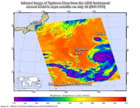
Infrared light provides scientists with temperature data and that's important when trying to understand how strong storms can be. The higher the cloud tops, the colder and the stronger they are. So infrared light as that gathered by the Atmospheric Infrared Sounder called AIRS can identify the strongest storms within a tropical cyclone.
On July 25 at 0311 UTC (July 24 at 11:11 p.m. EDT) AIRS captured infrared data on Noru, and found powerful thunderstorms with cloud top temperatures as cold as 210 kelvin (minus 81.6 Fahrenheit/minus 63.1 degrees Celsius) surrounding the eye. According to NASA research, cloud top temperatures that cold indicate thunderstorms with the potential to drop heavy rainfall.
By 11 a.m. EDT (1500 UTC) on July 25, Noru was located about 258 nautical miles east-northeast of Minami Tori Shima atoll. Its eye was located near 26.6 degrees north latitude and 158.1 degrees east longitude. Maximum sustained winds were near 80 knots (92 mph/148 kph) and was moving west at 6 knots (6.9 mph/11.1 kph).
Read more at NASA/Goddard Space Flight Center
Image: On July 25 at 0311 UTC (July 24 at 11:11 p.m. EDT) the AIRS instrument aboard NASA's Aqua satellite captured this infrared image of Typhoon Noru in the Northwestern Pacific Ocean. The image showed an area of powerful storms with very cold cloud tops (purple) surrounding the center. (Credit: NASA JPL/Ed Olsen)


