
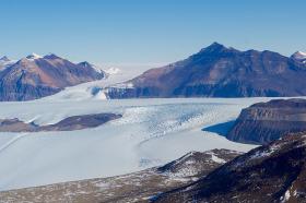
Portland State University researchers and the National Science Foundation (NSF) have publically released high-resolution maps of the McMurdo Dry Valleys, a globally unique Antarctic polar desert.
Portland State University researchers and the National Science Foundation (NSF) have publically released high-resolution maps of the McMurdo Dry Valleys, a globally unique Antarctic polar desert.
The PSU scientists led a team of researchers supported by the NSF to map the area using LIDAR technology. LIDAR, which stands for Light Detection and Ranging, is a remote sensing method that uses pulsed laser beams to measure the Earth’s surface and make precision elevation maps.
The maps cover 3,564 square kilometers of the McMurdo Dry Valleys and allow researchers to compare the present-day conditions with aerial surveys conducted almost 13 years ago.
The data, collected by aerial survey missions flown in the Southern Hemisphere summer of 2014-2015, provides detailed imagery of the perpetually ice-free region, where changes, such as rapid erosion along some streams, have been observed in recent years.
Read more at Portland State University
Photo credit: U.S. Department of State via Wikimedia Commons


.jpg)