Operation IceBridge is flying in Greenland to measure how much ice has melted over the course of the summer from the ice sheet. The flights, which began on Aug. 25 and will go on until Sept. 21, repeat paths flown this spring and aim to monitor seasonal changes in the elevation of the ice sheet.
Operation IceBridge is flying in Greenland to measure how much ice has melted over the course of the summer from the ice sheet. The flights, which began on Aug. 25 and will go on until Sept. 21, repeat paths flown this spring and aim to monitor seasonal changes in the elevation of the ice sheet.
“We started to mount these summer campaigns on a regular basis two years ago,” said Joe MacGregor, IceBridge’s deputy project scientist and a glaciologist with NASA’s Goddard Space Flight Center in Greenbelt, Maryland. “If the flights go as expected, the result will be a high-quality survey of some of the fastest melting areas in Greenland and across as much of the island as possible.”
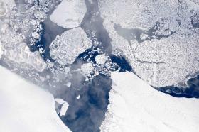
The image above was taken during a research flight carried on Aug. 29 and shows the calving front –the end of the glacier, from where it sheds chunks of ice– of the Zachariae Isstrom glacier in northeast Greenland. During the first week of the end-of-summer campaign, IceBridge was based in Thule Air Base, in northwest Greenland.
Continue reading at NASA / Goddard Space Flight Center
Image: Terminus of the Zachariæ Isstrøm glacier in northeast Greenland, as seen from 28,000 feet during an Operation IceBridge flight on Aug. 29, 2017
Image Credits: NASA/LVIS TEAM


