The Global Precipitation Measurement mission or GPM core satellite analyzed Hurricane Jose and found some very tall, powerful thunderstorms within, despite still being battered by wind shear as it moves between Bermuda and the Bahamas.
The Global Precipitation Measurement mission or GPM core satellite analyzed Hurricane Jose and found some very tall, powerful thunderstorms within, despite still being battered by wind shear as it moves between Bermuda and the Bahamas.
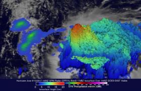
On Wednesday, Sept. 13 at 10:35 a.m. AST/EDT (1435 UTC) the GPM core observatory satellite traveled above persistent hurricane Jose as it was meandering in the Atlantic Ocean. GPM found that even though Jose was affected by strong northwesterly shear, it contained very powerful convective storms. GPM's Dual-Frequency Precipitation Radar (DPR) found extremely intense downpours within these storms where rain was measured by DPR falling at a rate of over 8.9 inches (227 mm) per hour.
At NASA's Goddard Space Flight Center in Greenbelt, Maryland, GPM's radar (DPR Ku Band) was used to create a 3-D cross-section of the precipitation within hurricane Jose. This 3-D examination by DPR showed that some of the powerful convective storms within Jose had tops that were reaching altitudes greater than 10.85 miles (175 km). GPM is a joint mission of NASA and the Japan Aerospace Exploration Agency, JAXA.
Read more at NASA/Goddard Space Flight Center
Image: On Sept. 13 at 10:35 a.m. EDT the GPM core observatory satellite found that even though Jose was affected by strong northwesterly shear, it contained very powerful convective storms. Intense downpours within these storms were falling at a rate of over 8.9 inches (227 mm) per hour. (Credit: NASA/JAXA, Hal Pierce)


