
Tropical Storm Norma is the newest addition to the tropical cyclones in the Eastern Pacific and NASA's Terra satellite caught it after it developed.
Tropical Storm Norma is the newest addition to the tropical cyclones in the Eastern Pacific and NASA's Terra satellite caught it after it developed.
Tropical Depression 15E lies to the west of Norma, and Hurricane Max lies to the east, and along the coast of southwestern Mexico. Norma formed quickly and is the seventeenth tropical cyclone of the Eastern Pacific Hurricane season.
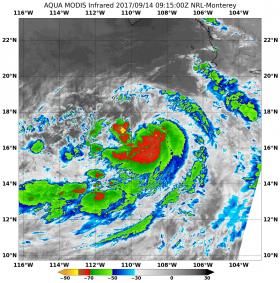
On Sept. 14 at 5:15 a.m. EDT (915 UTC) the Moderate Resolution Imaging Spectroradiometer or MODIS instrument aboard NASA's Aqua satellite provided an infrared image of Tropical Storm Norma. Infrared satellite imagery showed coldest cloud top temperatures were as cold as minus 70 degrees Fahrenheit (minus 56.6 degrees Celsius). NASA research indicates very cold cloud tops with the potential to generate very heavy rainfall.
Read more at NASA / Goddard Space Flight Center
Image: On Sept. 14 at 5:15 a.m. EDT (915 UTC) MODIS instrument aboard NASA's Aqua satellite provided an infrared image of Tropical Storm Norma that showed powerful thunderstorms with cloud top temperatures near minus 70F (red). Credits: NASA / NRL


