Hurricane Lee began weakening as NASA's Aqua satellite passed overhead and collected temperature information. Satellite data showed that Lee's strongest side was south of its center.
Hurricane Lee began weakening as NASA's Aqua satellite passed overhead and collected temperature information. Satellite data showed that Lee's strongest side was south of its center.
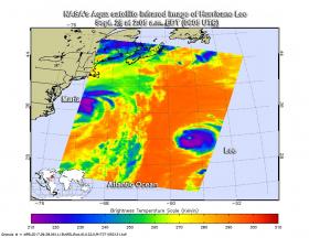
The Atmospheric Infrared Sounder or AIRS instrument aboard NASA's Aqua satellite passed over Hurricane Lee on Sept. 28 at 2:05 a.m. EDT (0605 UTC) and analyzed the storm in infrared light. Infrared light provides temperature data and that's important when trying to understand how strong storms can be. The higher the cloud tops, the colder and the stronger they are.
When Aqua passed over Lee, the AIRS instrument found coldest cloud top temperatures in thunderstorms mostly south of the center. Those temperatures were as cold as minus 63 degrees Fahrenheit (minus 53 degrees Celsius). Storms with cloud top temperatures that cold have the capability to produce heavy rainfall.
Read more at NASA/Goddard Space Flight Center
Image: NASA's Aqua satellite provided an infrared picture of Hurricane Lee's cloud top temperatures from Sept. 28 at 2:05 a.m. EDT (0605 UTC).
Credits: NASA JPL, Ed Olsen


