The East Antarctic Ice Sheet locks away enough water to raise sea level an estimated 53 meters (174 feet), more than any other ice sheet on the planet. It’s also thought to be among the most stable, not gaining or losing mass even as ice sheets in West Antarctica and Greenland shrink.
The East Antarctic Ice Sheet locks away enough water to raise sea level an estimated 53 meters (174 feet), more than any other ice sheet on the planet. It’s also thought to be among the most stable, not gaining or losing mass even as ice sheets in West Antarctica and Greenland shrink.
New research published on Nov. 14 in Nature led by The University of Texas at Austin and the University of South Florida found that the East Antarctic Ice Sheet may not be as stable as it seems. In fact, the ice sheet has a long history of expanding and shrinking — a finding that indicates the ice sheet may contribute substantially to global sea level rise as Earth’s climate warms. The new results came from geophysical and geological data collected during the first-ever oceanographic survey of East Antarctica’s Sabrina Coast. The glaciers in this region may be particularly susceptible to climate change because they flow from the Aurora Basin, a region of East Antarctica that mostly lies below sea level.
Co-lead author Sean Gulick, a research professor at the University of Texas Institute for Geophysics (UTIG) and the UT Department of Geological Sciences (DGS), said the study found that glaciers from the Aurora Basin have been stable only for the past few million years.
“It turns out that for much of the East Antarctic Ice Sheet’s history, it was not the commonly perceived large stable ice sheet with only minor changes in size over millions of years,” he said. “Rather, we have evidence for a very dynamic ice sheet that grew and shrank significantly between glacial and interglacial periods. There were also often long intervals of open water along the Sabrina Coast, with limited glacial influence.”
Read more at University of Texas at Austin
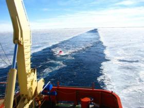
Image: The researchers deployed marine seismic technology from the back of an ice breaker near Antarctica's Sabrina Coast. The equipment captured images of the seafloor, including geological formations created by the ice sheet. This allowed the scientists to reconstruct how glaciers in the area have advanced and retreated over the past 50 million years. (Credit: Sean Gulick/University of Texas at Austin)


