
The remnants of Tropical Cyclone Fehi brought rain to New Zealand before it fizzled out. NASA and the Japan Aerospace Exploration Agency’s GPM core satellite provided a look at the rainfall from its vantage point in space.
The Joint Typhoon Warning Center (JTWC) issued its last warning for tropical cyclone Fehi on January 30, 2018 at 10 a.m. EST (1500 UTC) but its remnants battered New Zealand on January 31. The remnants of the tropical cyclone pounded New Zealand with high winds and occasionally heavy rain. Winds gusting to speeds of over 75 knots (86 mph) and 20 mm (.79 inches) of rain fell in 12 hours near Wellington, New Zealand. Flights were canceled, trees were knocked down and roads were flooded.
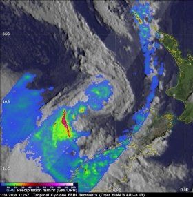
The GPM or Global Precipitation Measurement mission core observatory satellite had a good look at Fehi’s remnants as it was nearing New Zealand. GPM flew above the Tasman Sea on January 31, 2018 at 1725 UTC (February 1, 2018 at 6:25 a.m. NZDT). Rainfall data collected by GPM's Microwave Imager (GMI) and Dual Frequency Precipitation Radar (DPR) instruments showed rain moving onto the coast of New Zealand's South Island.
Read more at NASA/Goddard Space Flight Center
Image: On Jan. 31 at 1725 UTC (Feb. 1 at 6:25 a.m. NZDT) GPM saw rain moving onto the coast of New Zealand's South Island and extremely heavy rainfall in an intense band of storms southwest of the storm's center over the open waters of the Tasman Sea falling at over 268 mm (10.6 inches) per hour. (Credit: NASA/JAXA, Hal Pierce)


