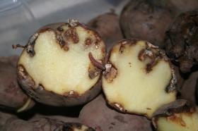
Former Tropical Depression 13E has strengthened into a Major Hurricane on the Saffir-Simpson Hurricane Wind Scale. NASA’s Terra satellite passed over Kenneth and captured an image that showed a well-developed storm with a visible eye.
On Friday, Aug. 18 at 11 p.m. EDT Tropical Depression 13E strengthened into Tropical Storm Kenneth. Just 48 hours later at 11 p.m. EDT on August 20, Kenneth became a hurricane.
The Moderate Resolution Imaging Spectroradiometer or MODIS instrument that flies aboard NASA’s Terra satellite captured a visible-light image of Kenneth at 4:30 p.m. EDT on Sunday, Aug. 20, 2017. It showed powerful thunderstorms wrapped around the center of the visible 15 nautical-mile wide eye. Infrared satellite imagery showed that the cloud tops of the surrounding ring of convection has cooled indicating they have strengthened as the storms have pushed higher into the troposphere.