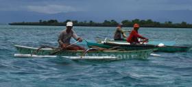
A new UBC study has found that small-scale fisheries may have a much larger impact on ocean ecosystems than previously thought, due to a lack of data on their development over time.
“We found that the influence from small-scale fisheries is far from small,” said Jennifer Selgrath, lead author who completed the research as a PhD student with UBC’s Institute for the Oceans and Fisheries and Project Seahorse. “In our case study in the Philippines, we found that the fisheries have become unsustainable because there are so many people trying to catch a limited number of fish and invertebrates.”