
How much water flows through a river has little influence over long-term changes to its course and the surrounding landscape, a study of waterfalls shows.

How much water flows through a river has little influence over long-term changes to its course and the surrounding landscape, a study of waterfalls shows.

For nearly two decades, scientists have noted dramatic changes in arctic tundra habitat. Ankle-high grasses and sedges have given way to a sea of woody shrubs growing to waist- or neck-deep heights. This shrubification of the tundra challenges animals like caribou that are adapted to low-stature arctic vegetation.

Today, when an enterprise wants to use machine learning to solve a problem, they have to call in the cavalry. Even a simple problem requires multiple data scientists, machine learning experts, and domain experts to come together to agree on priorities and exchange data and information.
This process is often inefficient, and it takes months to get results. It also only solves the problem immediate at hand. The next time something comes up, the enterprise has to do the same thing all over again.
One group of MIT researchers wondered, "What if we tried another strategy? What if we created automation tools that enable the subject matter experts to use ML, in order to solve these problems themselves?"
More than 11,000 people died during the Ebola outbreak in West Africa from 2013-16, demonstrating both the deadly nature of the virus and the limitations of the medication used to fight it.
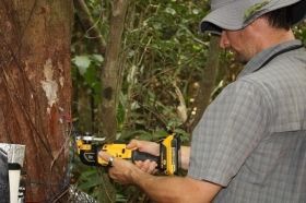
Tropical trees respond to drought differently depending on their ages, according to new research led by a postdoctoral scientist at the University of Wyoming.
Mario Bretfeld, who works in the lab of UW Department of Botany Professor Brent Ewers, is the lead author of an article that appears today (Monday) in the journal New Phytologist, one of the top journals in the field of plant controls over the water cycle. The research was conducted in collaboration with the Smithsonian Tropical Research Institute (STRI).

Scientists have developed a new therapy to combat deadly bacteria that is infecting hospital patients worldwide. The new therapy—a biocide that is able to target antibiotic-defiant bacteria such as Methicillin-resistant Staphylococcus aureus (MRSA)—was developed by scientists at the University of Waterloo and University of Manitoba. “We wanted to be able to help vulnerable patients suffering from chronic infections,” said Emmanuel Ho, a professor in the School of Pharmacy at the University of Waterloo. “Once they’re infected with a resistant strain of bacteria it’s very difficult to get them well again.”


