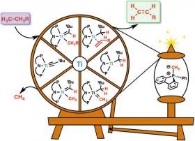
They are all around you! Most plastics, conductive polymers, and even medicines derive from molecules with a double bond between two carbon atoms, C=C. These molecules are called olefins and are mainly produced from fossil fuels through an energy-intensive and polluting process known as steam cracking. It requires temperatures of 800°C and produces the greenhouse gas carbon dioxide. Needless to day, alternatives to this process which could bring environmental and economic benefits are highly sought after.

Read more ...

Cell biologists at the University of Toronto have discovered animals can adapt their ability to see even with extreme changes in temperature.

The researchers looked deeply into the eyes of catfish living in cold-water streams at altitudes of up to nearly three kilometres in the Andes Mountains to find out how. Their findings are published in Proceedings of the National Academy of Sciences.

Read more ...

The intensive management of grasslands is bad for biodiversity. However, a study by the Terrestrial Ecology Research Group at the Technical University of Munich (TUM) has brought a ray of hope: If different forms of management are optimally distributed within a region, this can lead to higher yields without the loss of insect species. In ideal cases, this will allow even more species to find habitats that are optimal for them. What is crucial here is that management is planned at the landscape level.

Read more ...

Harvests from freshwater fisheries such as the Great Lakes could total more than 12 million tons a year globally and contribute more to global food supplies and economies than previous estimates indicate, according to a study published today by Michigan State University and the U.S. Geological Survey.

Read more ...

Shortly after lasers were first developed in the 1960s, LiDAR – whose name originated as a combination of “light” and “radar” – capitalized on the newly unique precision they offered for measuring both time and distance. LiDAR quickly became the standard method for (3-D) land surveys and is now used in a multitude of sensing applications, such as self-driving cars.
By scanning areas of land with lasers, often from airplanes, LiDAR’s travel-time measurements for light reflected back from the scanned area provide the distances that make up a resulting high-resolution topography.

Read more ...

More Articles ...

Subcategories