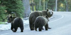
It’s simple math, says a University of Alberta conservation biologist. More roads equals fewer grizzly bears.
In a recent study examining a non-invasive DNA (hair collection) dataset of grizzly bear activity in British Columbia, Clayton Lamb and his colleagues determined what scientists have long suspected: higher road density leads to lower grizzly bear density—a critical problem for a species still rebounding from a long period of human persecution.