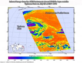
NASA's Aqua satellite provided a near-infrared look at Typhoon Noru as it continued its western track at sea, far to the southeast of Japan.

Near-infrared satellite imagery from the Atmospheric Infrared Sounder or AIRS instrument that flies aboard NASA's Aqua satellite taken on July 26 at 0211 UTC (July 25 at 10:11 p.m. EDT) showed provided a look at the temperatures of Noru’s clouds. That data was false colored and made into an image at NASA's Jet Propulsion Laboratory in Pasadena, California to highlight cloud top temperatures.

Read more ...

Tropical Storm Nesat formed early on July 26 just east of the Philippines and NASA's Aqua satellite passed overhead gathering temperature data to determine the location of the most powerful storms. Imagery showed strong storms from Nesat's western side were affecting the central Philippines.

Infrared satellite imagery from the Atmospheric Infrared Sounder or AIRS instrument that flies aboard NASA's Aqua satellite taken on July 26 at 0529 UTC (1:29 a.m. EDT) provided a look at the temperatures of Nesat’s clouds. That data was false colored and made into an image at NASA's Jet Propulsion Laboratory in Pasadena, California to highlight cloud top temperatures.

Read more ...

A lonely bird call breaks my concentration and I glance upward. Where glacier-topped mountains should be filling the horizon, instead my view is obscured by a strange orange haze. Even the bright sun has given up. It seems to float in the sky as a faint pink ball.

I am a field ecologist working east of the Denali mountain range in Alaska, but the postcard-worthy view of my sites today is obscured by smoke drifting across the border from wildfires burning throughout British Columbia. I have been studying boreal wildfires for years and have a strong understanding of the importance of fire to the boreal forest of Canada.

Read more ...

More Articles ...

Subcategories