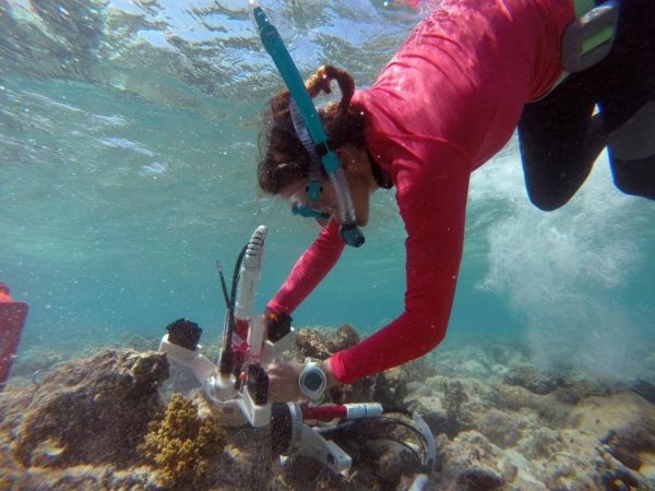
A Texas A&M professor, in collaboration with the University of Nebraska-Lincoln, received a Department of Energy grant to develop a system in engineered barriers to isolate and contain nuclear fuel waste.
articles
Drop in Pandemic CO2 Emissions Previews World of Electric Vehicles
When the pandemic forced Bay Area residents to shelter in place in March, chemist Ron Cohen saw an opportunity to see how air quality was affected.
Workshop Collaboration Aims to Move Tidal Marsh Research Forward
Tidal marshes play a significant role in coastal ecosystems. They are a nursery ground for juvenile fishes and a line of defense in coastal erosion.
Scientists Have Discovered an Ancient Lake Bed Deep Beneath the Greenland Ice
Scientists have detected what they say are the sediments of a huge ancient lake bed sealed more than a mile under the ice of northwest Greenland—the first-ever discovery of such a sub-glacial feature anywhere in the world. Apparently formed at a time when the area was ice-free but now completely frozen in, the lake bed may be hundreds of thousands or millions of years old, and contain unique fossil and chemical traces of past climates and life. Scientists consider such data vital to understanding what the Greenland ice sheet may do in coming years as climate warms, and thus the site makes a tantalizing target for drilling. A paper describing the discovery is in press at the journal Earth and Planetary Science Letters.
“This could be an important repository of information, in a landscape that right now is totally concealed and inaccessible,” said Guy Paxman, a postdoctoral researcher at Columbia University’s Lamont-Doherty Earth Observatory and lead author of the report. “We’re working to try and understand how the Greenland ice sheet has behaved in the past. It’s important if we want to understand how it will behave in future decades.” The ice sheet, which has been melting at an accelerating pace in recent years, contains enough water to raise global sea levels by about 24 feet.
The researchers mapped out the lake bed by analyzing data from airborne geophysical instruments that can read signals that penetrate the ice and provide images of the geologic structures below. Most of the data came from aircraft flying at low altitude over the ice sheet as part of NASA’s Operation IceBridge.
Read more at: Earth Institute at Columbia University
The largely featureless surface of the Greenland ice sheet, as seen from the window of a P3 aircraft carrying geophysical instruments aimed at detecting geologic features underneath. (Photo Credit: Kirsty Tinto/Lamont-Doherty Earth Observatory)
New Study Uses Satellites and Field Studies to Improve Coral Reef Restoration
Our planet’s coral reef ecosystems are in peril from multiple threats. Anthropogenic CO2 has sparked a rise in global average sea surface temperatures, pushing reef survival beyond its upper thermal limits.
Penn Researchers Present Findings on Cardiac Risks for Cancer Patients
Developments in cancer treatment and care have dramatically improved survival for cancer patients, however, these treatments can also damage other parts of the body, including the heart.