
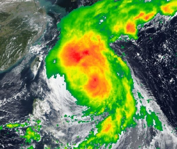
NASA’s IMERG combines data from many satellites to provide a look at rainfall occurring around the world. Those rainfall data were combined with visible imagery from NASA-NOAA’s Suomi NPP satellite to create a composite or fuller picture of Kong- Rey in the Northwestern Pacific Ocean as it weakened to a tropical storm.
NASA’s IMERG combines data from many satellites to provide a look at rainfall occurring around the world. Those rainfall data were combined with visible imagery from NASA-NOAA’s Suomi NPP satellite to create a composite or fuller picture of Kong- Rey in the Northwestern Pacific Ocean as it weakened to a tropical storm.
The Global Precipitation Measurement mission or GPM core satellite provided a look at distribution of rainfall within Kong-Rey. GPM is a joint mission between NASA and the Japan Aerospace Exploration Agency, JAXA. GPM found heaviest rain falling around the center and northwest of the center on Oct. 4, 2018.
The Visible Infrared Imaging Radiometer Suite (VIIRS) instrument aboard NASA-NOAA’s Suomi NPP satellite captured a visible light image that showed the western quadrant of Kong-Rey just east of Taiwan on Oct. 4.
Read more at NASA / Goddard Space Flight Center
Image: NASA’s IMERG and NASA-NOAA’s Suomi NPP satellite imagery were combined to create a picture of the extent and rainfall of Tropical Storm Kong-Rey. IMERG found heavy rain falling (red) around the center and northwest of the center on Oct. 3, 2018. CREDIT: NASA Worldview, Earth Observing System Data and Information System (EOSDIS) /NOAA/JAXA


