As Tropical Depression 4 was getting organized in the central Atlantic Ocean the Global Precipitation Measurement Mission or GPM satellite peered into the storm and measured rainfall within. The system became Tropical Depression 4 on July 6.
As Tropical Depression 4 was getting organized in the central Atlantic Ocean the Global Precipitation Measurement Mission or GPM satellite peered into the storm and measured rainfall within. The system became Tropical Depression 4 on July 6.
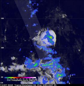
The GPM core observatory satellite flew over the low pressure system on July 5, 2017 at 5:47 a.m. EDT (0947 UTC). GPM's Microwave Imager (GMI) and Dual-frequency Precipitation Radar (DPR) showed that heavy showers were located in this area. GPM's GMI data indicated that rain was coming down at a rate of greater than 44.2 mm (1.74 inches) per hour in one cluster of storms. GPM's radar (DPR Ku band) measured precipitation falling at rate of over 116 mm (4.6 inches) per hour in a line of thunderstorms southwest of that cluster.
By 0300 UTC on July 6 (11 p.m. EDT on July 5), the low pressure area consolidated enough to be classified as a tropical depression.
At 0900 UTC (5 a.m. EDT) on July 6 the center of Tropical Depression Four was located near latitude 13.2 degrees north and longitude 40.0 degrees west. That's about 1,435 miles (2,305 km) east of the Lesser Antilles and far from land. The depression is moving toward the west-northwest near 16 mph (26 kph). A continued west-northwestward motion with an additional increase in forward speed is expected over the next 48 hours.
Read more at NASA/Goddard Space Flight Center
Image: On July 5, 2017 at 5:47 a.m. EDT (0947 UTC) the GPM satellite found precipitation falling at rate of over rain was coming down at a rate of greater than 44.2 mm (1.74 inches) per hour in one cluster of storms, southwest of that area, heavier rain was falling at 116 mm (4.6 inches) per hour. (Credit: NASA/JAXA, Hal Pierce)


