NASA satellites gave the Eastern Pacific Ocean's Hurricane Eugene an "eye exam" as it studied the storm in infrared and visible light. NASA satellite imagery taken at different times showed Eugene's eye open and closed.
NASA satellites gave the Eastern Pacific Ocean's Hurricane Eugene an "eye exam" as it studied the storm in infrared and visible light. NASA satellite imagery taken at different times showed Eugene's eye open and closed.
Despite its distance from land, Eugene was causing dangerous ocean swells along the western coast of Baja California on July 10.
Hurricane Eugene formed from a low pressure area that rapidly developed into a tropical storm on Friday, July 7, around 5 p.m. EDT (2100 UTC).
On Sunday, July 9, at 8 a.m. EDT (1200 UTC) NOAA's GOES-West infrared satellite imagery revealed an eye as the storm reached Category 2 status on the Saffir-Simpson Hurricane Wind Scale. Eugene as located about 565 miles (185 km) southwest of the southern tip of Baja California, Mexico, at the time.
Read more at NASA/Goddard Space Flight Center
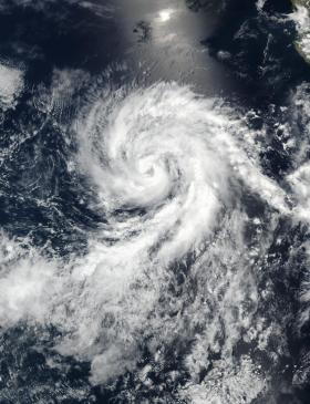
Image: NASA-NOAA's Suomi NPP satellite captured this visible light image of Tropical Storm Eugene off the western coast of Mexico on July 9, 2017, at 4:30 p.m. EDT (2030 UTC). The image showed that the eye had become cloud-filled. (Credit: NOAA/NASA Goddard Rapid Response)


