Jose continues to bring tropical storm conditions to southern New England although the storm has become post-tropical. NASA's Terra satellite caught a view of the storm sitting almost stationary about 100 miles from Nantucket Island, Massachusetts.
Jose continues to bring tropical storm conditions to southern New England although the storm has become post-tropical. NASA's Terra satellite caught a view of the storm sitting almost stationary about 100 miles from Nantucket Island, Massachusetts.
On Sept. 21 at 11:25 a.m. EDT (1525 UTC), the MODIS instrument or Moderate Resolution Imaging Spectroradiometer aboard NASA's Terra satellite took a visible picture of Jose. The image showed Jose's clouds in the northwestern quadrant continued sweep over southern New England, southeastern New York, and northeastern New Jersey. Jose is a large storm and the clouds in its northeastern quadrant are just south of Nova Scotia, Canada. Tropical-storm-force winds extend outward up to 220 miles (350 km) from the center.
Jose formed on Sept. 2 and has been around 20 days. The National Hurricane Center issued their 68th advisory on Jose on Sept. 22.
A Tropical Storm Warning is in effect for Woods Hole to Sagamore Beach, including Cape Cod, Massachusetts, Block Island, Martha's Vineyard and Nantucket Island.
Read more at NASA/Goddard Space Flight Center
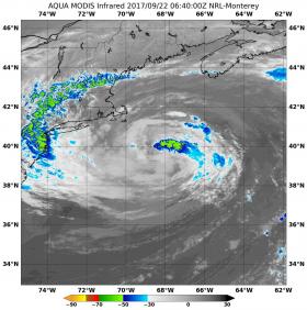
Image: NASA's Aqua satellite observed Jose in infrared light that revealed cloud top temperatures on Sept. 22 at 2:40 a.m. EDT (6:40 UTC) were coldest (yellow) and as cold as minus 50 degrees Fahrenheit (minus 45.5 degrees Celsius). (Credit: NASA/NRL)


