Severe weather that rolled through the Ohio Valley on Nov. 5 was analyzed by NASA's Global Precipitation Measurement mission or GPM satellite. GPM provided forecasters at the National Weather Service with rain rates and cloud heights that showed where strongest storms were located.
Severe weather that rolled through the Ohio Valley on Nov. 5 was analyzed by NASA's Global Precipitation Measurement mission or GPM satellite. GPM provided forecasters at the National Weather Service with rain rates and cloud heights that showed where strongest storms were located.
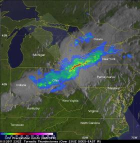
Tornadoes were reported on the evening of Sunday, Nov. 5 in Illinois, Indiana and Ohio. At least nine twisters were reported between 2:40 PM EDT and 7:22 PM EDT (1840 - 2322 UTC). This unsettled weather caused many customers to lose electric power in northern Ohio. One powerful storm injured eight people in the northern Ohio town of Celina.
Continue reading at NASA / Goddard Space Flight Center
Image: On Nov. 5, GPM'S radar showed that some storms near the northeastern Ohio and northwestern Pennsylvania borders were dropping rain at a rate of greater than 3.6 inches (92 mm) per hour.
Image Credits: NASA / JAXA, Hal Pierce


