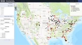
A new U.S. Geological Survey interactive map provides a comprehensive, long-term look at changes in the quality of our nation’s rivers and streams over the last four decades. For the first time, monitoring data collected by the USGS and 73 other organizations at almost 1,400 sites have been combined to provide a nationwide look at changes in the quality of our rivers and streams between the 1972 passage of the Clean Water Act and 2012.
>> Read the Full Article

Computers used to require entire buildings to operate. Now they fit in our pockets. Similarly, factory-size electronics manufacturing is approaching a contraction. Want proof? Look at that $50 printer on your desk and imagine, instead of using it to spit out a hard copy of that thank-you note, that you used it to print some digital memory.
>> Read the Full Article
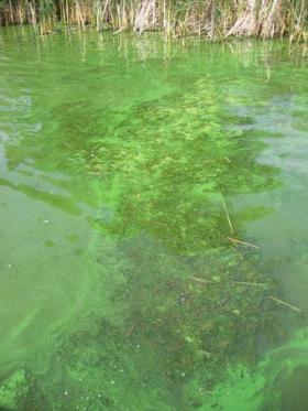
Two decades of harmful algal bloom, nutrient and sediment research by the U.S. Geological Survey is helping to support Wichita’s long-term vision of a sustainable water supply into the future. Early warning indicators of harmful algal blooms have been developed for Cheney Reservoir, Kansas, according to a new USGS publication done in cooperation with the City of Wichita, Kansas.
>> Read the Full Article
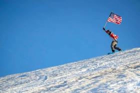
Skiing in July? It could happen this year, but California’s days of bountiful snow are numbered.
After five years of drought and water restrictions, the state is reeling from its wettest winter in two decades. Moisture-laden storms have turned brown hillsides a lush green and state reservoirs are overflowing. There’s so much snow, Mammoth Mountain resort plans to be open for business on Fourth of July weekend.
>> Read the Full Article


