
Archaeologists have published a new map showing an extensive ancient settlement surrounding Cambodia's Angkor Wat that supported large numbers of inhabitants before and after the famous temple was built.
HONG KONG - Archaeologists have published a new map showing an extensive ancient settlement surrounding Cambodia's Angkor Wat that supported large numbers of inhabitants before and after the famous temple was built.
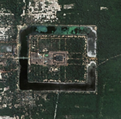
Now obscured by vegetation and low-lying clouds, the ruins spread over 1,000 sq km and were made up of thousands of houses, roads, manmade ponds and canals, researchers from Australia, Cambodia and France said in the latest issue of the Proceedings of the National Academy of Sciences.
"We now know that instead of being just (a collection of) temples, Angkor was actually a continuous and interconnected network of temples and small scale residential features like small village ponds, small village temples as well," Damien Evans of the Archaeological Computing Laboratory at the University of Sydney told Reuters in a telephone interview.
"Very little remains now, they are just piles of brick ... a thousand years ago (it) would have been a huge and popular city, full of life, rather than this image of temples in a jungle."
Angkor Wat was built in the early 12th century, while the settlement existed between 500 AD and 1500 AD, Evans said.
!ADVERTISEMENT!
"What we can see, even on a preliminary basis, is that several hundred thousand people must have lived in the Angkor area ... which is defined by the infrastructure, the roads, the canals, huge embankments," he added.
Using hand-drawn maps, ground surveys, satellite imagery, aerial photography and ground-sensing radar provided by NASA, the researchers identified what they believed to be more than a thousand former manmade ponds, temples and moats -- all of which were now replaced by vegetation.
Ranging from 20 meters to 8 km long, the ponds were used for drinking, irrigation, livestock and other domestic purposes and were especially crucial for the dry season.
"The slightly lower elevations of the rice fields in the former moats and reservoirs ... result in different stages of rice maturity and in differential levels of soil moisture content, which strongly affect the returned radar signal," Evans said. "You get more mature rice in these wetter areas."
The researchers believe the settlement was abandoned around 1500 AD because of overexploitation and deforestation.
"What our work proved for the first time was that Angkor certainly was large enough and its water management system was complex and extensive enough to have created very serious environmental problems," Evans said.
"In such situations, infrastructure becomes very important and increasingly complex and difficult to maintain."
Future studies will look at how serious these problems were and if the inhabitants were able to deal with them.


