
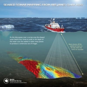
Using sonar technology from onboard ships, scientists from British Antarctic Survey (BAS) and the German Alfred Wegener Institute (AWI) captured the most extensive, continuous set of images of the seafloor around the Amundsen Sea embayment ever taken.
Motorway-sized troughs and channels carved into Antarctica's continental shelves by glaciers thousands of years ago could help scientists to predict future sea-level rise according to a report in the journal Geology this month (May).
Using sonar technology from onboard ships, scientists from British Antarctic Survey (BAS) and the German Alfred Wegener Institute (AWI) captured the most extensive, continuous set of images of the seafloor around the Amundsen Sea embayment ever taken. This region is a major drain point of the West Antarctic Ice Sheet (WAIS) and considered by some scientists to be the most likely site for the initiation of major ice sheet collapse.
!ADVERTISEMENT!
The sonar images reveal an 'imprint' of the Antarctic ice sheet as it was at the end of the last ice age around 10 thousand years ago. The extent of ice covering the continent was much larger than it is today. The seabed troughs and channels that are now exposed provide new clues about the speed and flow of the ice sheet. They indicate that the controlling mechanisms that move ice towards the coast and into the sea are more complex than previously thought.


