
The most comprehensive picture of the rapidly thinning glaciers along the coastline of both the Antarctic and Greenland ice sheets has been created using satellite lasers. The findings are an important step forward in the quest to make more accurate predictions for future sea level rise.
The most comprehensive picture of the rapidly thinning glaciers along the coastline of both the Antarctic and Greenland ice sheets has been created using satellite lasers. The findings are an important step forward in the quest to make more accurate predictions for future sea level rise.
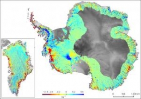
Reporting this week in the journal Nature, researchers from British Antarctic Survey and the University of Bristol describe how analysis of millions of NASA satellite measurements* from both of these vast ice sheets shows that the most profound ice loss is a result of glaciers speeding up where they flow into the sea.
!ADVERTISEMENT!
The authors conclude that this 'dynamic thinning' of glaciers now reaches all latitudes in Greenland, has intensified on key Antarctic coastlines, is penetrating far into the ice sheets' interior and is spreading as ice shelves thin by ocean-driven melt. Ice shelf collapse has triggered particularly strong thinning that has endured for decades.
Image is a new comprehensive map of Greenland and Antarctica that shows extent of glacier thinning. (Credit: ICESat, NASA)
Article continues: http://www.sciencedaily.com/releases/2009/09/090923143331.htm


