
There are many mysteries about this small island in the southeast Pacific. The biggest ones are about the strange large statutes and how they were moved about and the second about how it all ended on this lonely island. Archaeologists have now disproved the fifty year old original theory underpinning our understanding of how the famous stone statues were moved around Easter Island. Fieldwork led by researchers at University College London and The University of Manchester, has shown the remote Pacific island’s ancient road system was primarily ceremonial and not solely built for transportation of the figures.
There are many mysteries about this small island in the southeast Pacific. The biggest ones are about the strange large statutes and how they were moved about and the second about how it all ended on this lonely island. Archaeologists have now disproved the fifty year old original theory underpinning our understanding of how the famous stone statues were moved around Easter Island. Fieldwork led by researchers at University College London and The University of Manchester, has shown the remote Pacific island’s ancient road system was primarily ceremonial and not solely built for transportation of the figures.
!ADVERTISEMENT!Easter Island once had vast forests and growing strong population, civilized enough to make these giant statues. Climate change has been proposed as a possible factor in the ecological changes.
Jared Diamond dismisses past climate change as a dominant factor on the island's deforestation in his book Collapse which offers his perspective into the collapse of the ancient Easter Islanders. He states that the disappearance of the island's trees seems to coincide with a decline of its civilization around the 17th and 18th century. This is linked to the fact that they stopped making statues at that time and started destroying the them.
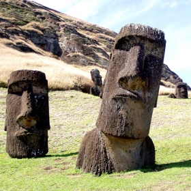
A complex ancient network of roads up to 800 years old crisscross the Island between the hat and statue quarries and the coastal areas. Laying alongside the roads are dozens of the statues- or moai. The original theory was that the roads were for transport of the moai only and what laid along side the roads were the ones lost in transport.
The find will create controversy among the many archaeologists who have dedicated years to finding out exactly how the moai were moved, ever since Norwegian adventurer Thor Heyerdahl first published his theory in 1958.
Instead, their discovery of stone platforms associated with each fallen moai - using non-invasive geophysical survey equipment such as ground penetrating radar and conductivity probes – finally confirms a little known 1914 theory of British archaeologist Katherine Routledge that the routes were primarily ceremonial avenues.
The statues merely toppled from the platforms with the passage of time and.or human intervention such as warfare.
â€What we do now know is that the roads had a ceremonial function to underline their religious and cultural importance. They lead – from different parts of the island – to the Rano Raraku volcano where the Moai were quarried.
“Volcano cones were considered as points of entry to the underworld and mythical origin land Hawaiki. Hence, Rano Ranaku was not just a quarry but a sacred center of the island.â€
And as the roads approach Rano Raraku, the statues become more frequent – which the team suggests meant an increasing grades of holiness.
“It all makes sense: the moai face the people walking towards the volcano. The statues are more frequent the closer they are to the volcano – which has to be way of signifying the increasing levels of importance.â€
For further information: http://www.manchester.ac.uk/aboutus/news/display/?id=5722


