
Remember the debate about the subsurface "plumes" or oil released by the leaking BP well in the Gulf of Mexico? A new report released by the National Oceanic and Atmospheric Administration (NOAA), the U.S. Environmental Protection Agency (EPA) and the White House Office of Science and Technology Policy about subsurface oil monitoring in the Gulf of Mexico contains preliminary data collected at 227 sampling stations extending from one to 52 kilometers from the Deepwater Horizon/BP wellhead. The data shows that the movement of subsurface oil is consistent with ocean currents and that the concentrations continue to be more diffuse as you move away from the source of the leak. This confirms the findings of the previous report. The report comes from the Joint Analysis Group (JAG), which is comprised of the afore mentioned agencies and was established to facilitate cooperation and coordination among the best scientific minds across the government and provide a coordinated analysis of information related to subsea monitoring in the Gulf of Mexico.
Remember the debate about the subsurface "plumes" or oil released by the leaking BP well in the Gulf of Mexico? A new report released by the National Oceanic and Atmospheric Administration (NOAA), the U.S. Environmental Protection Agency (EPA) and the White House Office of Science and Technology Policy about subsurface oil monitoring in the Gulf of Mexico contains preliminary data collected at 227 sampling stations extending from one to 52 kilometers from the Deepwater Horizon/BP wellhead.
The data shows that the movement of subsurface oil is consistent with ocean currents and that the concentrations continue to be more diffuse as you move away from the source of the leak. This confirms the findings of the previous report.
!ADVERTISEMENT!
The report comes from the Joint Analysis Group (JAG), which is comprised of the afore mentioned agencies and was established to facilitate cooperation and coordination among the best scientific minds across the government and provide a coordinated analysis of information related to subsea monitoring in the Gulf of Mexico.
The JAG report contains data analysis of fluorometric measurements and comments on the methods used to monitor dissolved oxygen levels. Data were collected on the R/V Brooks McCall, R/V Ocean Veritas, R/V Walton Smith, NOAA Ship Thomas Jefferson and NOAA Ship Gordon Gunter between May 19 and June 19, 2010. The fluorometric data provide additional information on the likely presence of sub-surface oil and its location in the water column. The report indicates that subsurface oil concentrations are highest near the wellhead and become more diffuse farther away from the source.
Over the course of multiple research missions conducted in the last three months, scientists have employed and tested many techniques to better understand the extent of this unprecedented oil spill and have found fluorometric sampling to be useful to help identify the location and concentration of subsurface oil. Fluorometers use light waves to detect anomalies in the water column. Researchers deployed water sampling devices in areas where the anomalies were detected to collect samples which are undergoing chemical analysis in the labs to determine the actual levels of hydrocarbons present.
Conclusions based on the fluorometric data in the report include:
- Fluorometry measurements show repeated signals between approximately 3,300 feet (1,000 meters) and 4,300 feet (1,300 meters) deep that are consistent with diffused oil in the water.
- The fluorometric signal is strongest near the wellhead and decreases with distance, which is consistent with previous sampling.
- Average fluorescence in the depths of interest – 3,300 feet and 4,300 feet – at sampled locations range from 4 to 7 parts per million (ppm). This estimated value is slightly higher than the laboratory-confirmed values previously reported by the JAG, which at their highest, near the wellhead, were approximately 1 to 2 ppm.
- It is important to note that fluorescence techniques also detect other natural organic substances in the water, leading to the existence of a background level of fluorescence throughout the water column. This means that the measured fluorometer signal is not solely attributable to Deepwater Horizon/BP oil.
- For the areas sampled, the fluorescence data indicate movement primarily west-southwest until June 2. In mid-June, fluorescence indicates movement toward the northeast within the Gulf. These movements are generally consistent with observed ocean currents in the area.
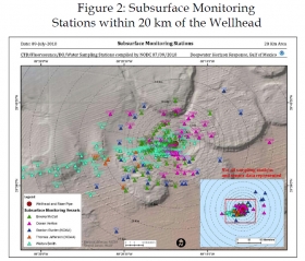
Image shows subsurface monitoring stations within 20 km of the Wellhead. Joint Analysis Group (JAG) Review of Preliminary Data to Examine Subsurface Oil In the Vicinity of MC252#1 May 19 to June 19, 2010.
Credit: NOAA
For more information: http://www.noaanews.noaa.gov/stories2010/20100722_jag.html


