
A century ago an astronomer by the name of Lowell "discovered" the canals of Mars. Since then better images has shown that there are no canals. Now a camera aboard NASA's Mars Odyssey spacecraft has helped develop the most accurate global Martian map ever. Researchers and the public can access the map via several websites and explore and survey the entire surface of the Red Planet and imagine what it might be on the surface.
A century ago an astronomer by the name of Lowell "discovered" the canals of Mars. Since then better images has shown that there are no canals. Now a camera aboard NASA's Mars Odyssey spacecraft has helped develop the most accurate global Martian map ever. Researchers and the public can access the map via several websites and explore and survey the entire surface of the Red Planet and imagine what it might be on the surface.
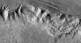
!ADVERTISEMENT!The map was constructed using nearly 21,000 images from the Thermal Emission Imaging System, or THEMIS, a multi-band infrared camera on Odyssey. Researchers at Arizona State University's Mars Space Flight Facility in Tempe, in collaboration with NASA's Jet Propulsion Laboratory in Pasadena, Calif., have been compiling the map since the THEMIS observations began eight years ago.
The pictures have been smoothed and blended to make a giant mosaic image. Users can pan around images and zoom down into them. At full zoom, the smallest surface details are 100 meters (330 feet) wide which is the size of a football field. While portions of Mars have been mapped at higher resolution, this map provides the most accurate view so far of the entire planet.
Advanced users with large bandwidth, powerful computers and software capable of handling images in the gigabyte range can download the full-resolution map in sections at: http://www.mars.asu.edu/data/thm_dir_100m .
"We've tied the images to the cartographic control grid provided by the U.S. Geological Survey, which also modeled the THEMIS camera's optics," said Philip Christensen, principal investigator for THEMIS and director of the Mars Space Flight Facility. "This approach lets us remove all instrument distortion, so features on the ground are correctly located to within a few pixels and provide the best global map of Mars to date."
Working with THEMIS images from the new map, the public can contribute to Mars exploration by going to the NASA's "Be a Martian" website: http://beamartian.jpl.nasa.gov/maproom#/MapMars. Here one can become a Martian citizen and explore maps and many related questions and answers about Mars. Here one can discuss the original finding of Lowell, ancient myths about Mars, and how one day it may be possible to visit and live on Mars.
"The Mars Odyssey THEMIS team has assembled a spectacular product that will be the base map for Mars researchers for many years to come," said Jeffrey Plaut, Odyssey project scientist at JPL. "The map lays the framework for global studies of properties such as the mineral composition and physical nature of the surface materials."
Other sites build upon the base map. At Mars Image Explorer, which includes images from every Mars orbital mission since the mid-1970s, users can search for images using a map of Mars at: http://themis.asu.edu/maps .
"The broad purpose underlying all these sites is to make Mars exploration easy and engaging for everyone," Christensen said. "We are trying to create a user friendly interface between the public and NASA's Planetary Data System, which does a terrific job of collecting, validating and archiving data."
So whether one wants only to see the Valles Marineris, Nix Olympica or search for the canals of Mars, these maps are the place to be.
For further information: http://www.jpl.nasa.gov/news/news.cfm?release=2010-244&rn=news.xml&rst=2680


