
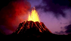
The Kilauea volcano that recently erupted on the Big Island of Hawaii will be the target for a NASA study to help scientists better understand processes occurring under Earth's surface. Kīlauea is an active volcano in the Hawaiian Islands, one of five shield volcanoes that together form the island of Hawaii. It is the most recent of a series of volcanoes that have created the Hawaiian archipelago, as the Pacific Plate moves over the Hawaii hotspot. Kīlauea is one of the most active volcanoes on the planet and an invaluable resource for volcanologists who are able to study it up close due to its exclusively non-violent effusive activity. Since 2008, rising emissions of sulfur dioxide from the Halemaʻumaʻu crater at Kīlauea's summit have led to increased levels of volcanic smog and local air quality concerns.
The Kilauea volcano that recently erupted on the Big Island of Hawaii will be the target for a NASA study to help scientists better understand processes occurring under Earth's surface. Kīlauea is an active volcano in the Hawaiian Islands, one of five shield volcanoes that together form the island of Hawaii. It is the most recent of a series of volcanoes that have created the Hawaiian archipelago, as the Pacific Plate moves over the Hawaii hotspot. Kīlauea is one of the most active volcanoes on the planet and an invaluable resource for volcanologists who are able to study it up close due to its exclusively non-violent effusive activity. Since 2008, rising emissions of sulfur dioxide from the Halemaʻumaʻu crater at Kīlauea's summit have led to increased levels of volcanic smog and local air quality concerns.
!ADVERTISEMENT!
KÄ«lauea is the youngest and southeastern most volcano on the Big Island of Hawaii. Topographically KÄ«lauea appears as only a bulge on the southeastern flank of Mauna Loa, and so for many years KÄ«lauea was thought to be a mere satellite of its giant neighbor, not a separate volcano. However, research over the past few decades shows clearly that KÄ«lauea has its own magma-plumbing system, extending to the surface from more than 60 kilometers deep in the earth.
A NASA Gulfstream-III aircraft equipped with a synthetic aperture radar developed by NASA's Jet Propulsion Laboratory in Pasadena, Calif., is scheduled to depart Sunday, April 3, from the Dryden Aircraft Operations Facility in Palmdale, Calif., to the visit Hawaii for a nine-day mission.
The Uninhabited Aerial Vehicle Synthetic Aperture Radar, or UAVSAR, uses a technique called interferometric synthetic aperture radar that sends pulses of microwave energy from the aircraft to the ground to detect and measure very subtle deformations in Earth's surface, such as those caused by earthquakes, volcanoes, landslides and glacier movements.
As the Gulfstream-III flies at an altitude of about 41,000 feet, the radar, located in a pod under the aircraft's belly, will collect data over Kilauea. The UAVSAR's first data acquisitions over this volcanic region took place in January 2010, when the radar flew over the volcano daily for a week. The UAVSAR detected deflation of Kilauea's caldera over one day, part of a series of deflation-inflation events observed at Kilauea as magma is pumped into the volcano's east rift zone.
This month's flights will repeat the 2010 flight paths to help compare these camera-like images, so as to reveal changes in Earth's surface.
"The April 2011 UAVSAR flights will capture the March 2011 fissure eruption surface displacements at high resolution and from multiple viewing directions, giving us an improved resolution of the magma injected into the east rift zone that caused the eruption," said JPL research scientist Paul Lundgren.
This injection of magma takes the form of a dike, a thin blade-like sheet of magma extending from the surface to several kilometers depth, with an opening of only a few meters.
Kilauea also releases massive amounts of sulfur dioxide which reacts chemically with sunlight, oxygen, dust particles, and water in the air to form a mixture of sulfate aerosols (tiny particles and droplets), sulfuric acid (H2SO4), and other oxidized sulfur species. Together, this gas and aerosol mixture produces a hazy atmospheric condition known as volcanic smog or "vog."
Strong trade winds blow the vog towards the southwest and the southern part of the Island of Hawaii. The cloud consists primarily of water vapor and sulfur dioxide. Note that the cloud rises only a few hundred feet above the ground. The direction and velocity of the prevailing wind largely determine the intensity and general location of vog conditions on the Island of Hawaii.
For further information: http://www.jpl.nasa.gov/news/news.cfm?release=2011-105&rn=news.xml&rst=2959 or http://hvo.wr.usgs.gov/kilauea/ or http://volcanoes.usgs.gov/hazards/gas/volgaspollution.php


