
A NASA-led team has used radar sounding technology developed to explore the subsurface of Mars to create high-resolution maps of freshwater aquifers buried deep beneath an Earth desert, in the first use of airborne sounding radar for aquifer mapping. The research may help scientists better locate and map Earth's desert aquifers, understand current and past hydrological conditions in Earth's deserts and assess how climate change is impacting them. Deserts cover roughly 20 percent of Earth's land surface, including highly populated regions in the Arabian Peninsula, North Africa (Sahara), west and central Asia (Takla Makan) and the southwestern United States (Sonora).
A NASA-led team has used radar sounding technology developed to explore the subsurface of Mars to create high-resolution maps of freshwater aquifers buried deep beneath an Earth desert, in the first use of airborne sounding radar for aquifer mapping. The research may help scientists better locate and map Earth's desert aquifers, understand current and past hydrological conditions in Earth's deserts and assess how climate change is impacting them. Deserts cover roughly 20 percent of Earth's land surface, including highly populated regions in the Arabian Peninsula, North Africa (Sahara), west and central Asia (Takla Makan) and the southwestern United States (Sonora).
!ADVERTISEMENT!
Fossil water or paleowater is groundwater that has remained sealed in an aquifer for a long period of time. Water can rest underground in "fossil aquifers" for thousands or even millions of years. When changes in the surrounding geology seal the aquifer off from further replenishing from precipitation, the water becomes trapped within, and is known as fossil water.
The Nubian Sandstone Aquifer System is among the most notable of fossil water reserves. Fossil aquifers also exist in the Sahara, the Kalahari, and the Ogallala underlying the US Great Plains. A further potential store of ancient water is Lake Vostok, a subglacial lake in Antarctica.
Fossil water is a non-renewable resource. Whereas most aquifers are naturally replenished by infiltration of water from precipitation, fossil aquifers get very little recharge. The extraction of water from such non-replenishing groundwater reserves (known as low safe-yield reserves) is known in hydrology as "water mining". If water is pumped from a well at a withdrawal rate that exceeds the natural recharge rate (which is very low or zero for a fossil aquifer), the water table drops, forming a depression in the water levels around the well. Water mining has been blamed for contributing to rising sea levels.
An international team led by research scientist Essam Heggy of NASA's Jet Propulsion Laboratory, Pasadena, Calif., recently traveled to northern Kuwait to map the depth and extent of aquifers in arid environments using an airborne sounding radar prototype. The 40-megahertz, low-frequency sounding radar was provided by the California Institute of Technology in Pasadena; and the Institut de Physique du Globe de Paris, France. Heggy's team was joined by personnel from the Kuwait Institute for Scientific Research (KISR), Kuwait City.
For two weeks, the team flew a helicopter equipped with the radar on 12 low-altitude passes (1,000 feet, or 305 meters) over two well-known freshwater aquifers, probing the desert subsurface down to the water table at depths ranging from 66 to 213 feet (20 to 65 meters). The researchers successfully demonstrated that the radar could locate subsurface aquifers, probe variations in the depth of the water table, and identify locations where water flowed into and out of the aquifers.
The radar is sensitive to changes in electrical characteristics of subsurface rock, sediments and water- saturated soils. Water-saturated zones are highly reflective and mirror the low-frequency radar signal. The returned radar echoes explored the thick mixture of gravel, sand and silt that covers most of Kuwait's northern desert and lies above its water table.
The team created high-resolution cross sections of the subsurface, showing variations in the fresh groundwater table in the two aquifers studied. The radar results were validated with ground measurements performed by KISR.
Heggy said most recent observations, scientific interest and data analyses of global warming have concentrated on Earth's polar regions and forests, which provide direct measurable evidence of large-scale environmental changes. Arid and semi-arid environments, which represent a substantial portion of Earth's surface, have remained poorly studied. Yet water scarcity and salt content, changes in rainfall, flash floods, high rates of aquifer exploitation and growth of desert regions are all signs that suggest climate change and human activities are also affecting these arid and semi-arid zones.
The radar sounding prototype shares similar characteristics with two instruments flying on Mars-orbiting spacecraft: Mars Advanced Radar for Subsurface and Ionospheric Sounding (MARSIS), on the European Space Agency's Mars Express, and Shallow Radar (SHARAD), on NASA's Mars Reconnaissance Orbiter. MARSIS, jointly developed by JPL and the Italian Space Agency, probes the Martian subsurface sediments and polar ice caps to a maximum depth of about 1.9 miles (3 kilometers). SHARAD, also built by the Italian Space Agency, looks for liquid or frozen water in the first few hundred feet of Mars' crust and probes Mars' polar caps. Both instruments have found evidence of ice in the Martian subsurface, but have not yet detected liquid water. The Kuwait results may lead to revised interpretations of data from these two instruments.
The research follows earlier work by JPL scientists to probe the subsurface of the Sahara desert using higher-frequency Synthetic Aperture Radar instruments flown onboard three space shuttle missions in 1981, 1984 and 1994. That work located shallow drainage networks and large dry basins, suggesting the Sahara has had extensive surface water activity in its recent geological past.
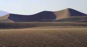
Kuwait's well-mapped shallow aquifers and flat surface provided the team with an ideal test location. Extreme dryness, such as that present in this region of Kuwait, is necessary to allow the radar's waves to penetrate deep into the surface and reflect on water-saturated layers beneath. Kuwait's flat topography and low radio noise also reduced clutter and improved the radar signal's return.
For further information: http://www.jpl.nasa.gov/news/news.cfm?release=2011-290&rn=news.xml&rst=3140


