On Oct. 9 an underwater volcano started to emerge in waters off El Hierro Island in the Canaries, Spain. The volcanic cone has reached a height of 100 m and the lava tongue flows down its side, even though its activity has slowed down in the past few days. The base of the volcano lies at a depth of 300 m. It is conical and 100 m high with a base diameter of 700 m and a crater width of 120 m. The volume of the volcano is around 0.012 km3, 0.07 km3 of which is made up of its lava tongue that is slowly filling the adjacent valley. Whether the eruption near the archipelago off the northwest coast of Africa will ever actually result in new land remains uncertain. But it's clear that the magma reservoir under El Hierro is simmering unchecked, constantly pouring out magma and causing the ground to shake several times a day. Since July, there have been more than 10,000 earthquakes (mostly imperceptible) on El Hierro.
On Oct. 9 an underwater volcano started to emerge in waters off El Hierro Island in the Canaries, Spain. The volcanic cone has reached a height of 100 m and the lava tongue flows down its side, even though its activity has slowed down in the past few days. The base of the volcano lies at a depth of 300 m. It is conical and 100 m high with a base diameter of 700 m and a crater width of 120 m. The volume of the volcano is around 0.012 km3, 0.07 km3 of which is made up of its lava tongue that is slowly filling the adjacent valley. Whether the eruption near the archipelago off the northwest coast of Africa will ever actually result in new land remains uncertain. But it's clear that the magma reservoir under El Hierro is simmering unchecked, constantly pouring out magma and causing the ground to shake several times a day. Since July, there have been more than 10,000 earthquakes (mostly imperceptible) on El Hierro.
!ADVERTISEMENT!
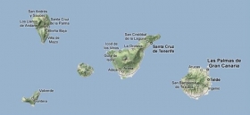
El Hierro, nicknamed Isla del Meridiano (the "Meridian Island"), is the smallest and farthest south and west of the Canary Islands in the Atlantic Ocean off the coast of Africa, with a population of 10,162 (2003).
There is evidence of at least three major landslides that have affected El Hierro in the last few hundred thousand years. The most recent of these was the 'El Golfo' landslide that occurred about 15 thousand years ago, involving collapse of the northern flank of the island. The landslide formed the El Golfo valley.
The Instituto Vulcanológico de Canarias (Volcanological Institute of the Canary Islands) and National Geographic Institute’s seismic monitoring station located in Valverde detected increase seismic activity beginning on 17 July 2011. The seismic monitoring network was increased in density on July 21 to allow better detection and location of the seismic events. There was an earthquake swarm with in excess of 400 minor tremors between 20 July and 24 July. By the end of September, the tremors had increased in frequency and intensity, with experts fearing landslides affecting the town of La Frontera, and also a small possibility of a volcanic eruption through a new vent.
It hasn't yet reached the surface, but residents of the Canary Islands have taken to the internet to suggest names for a potential new islet. There are already more than 500 suggestions. Favorites include "The Discovery," "Atlantis" and "The Best." Meanwhile Spanish newspapers are taking a different approach to the subject, debating who would take responsibility for the new territory.
For further information: http://freeinternetpress.com/story/Underwater-Lava-Eruptions-Could-Create-New-Island-In-The-Canaries-32414.html or http://live.kyero.com/2011/10/14/risk-of-eruption-increases-on-el-hierro/ or http://www.eurekalert.org/pub_releases/2011-10/f-sf-mtf_2102811.php
Photo: http://www.lanzaroteinformation.com/files/El%20Hierro_2.jpg


