
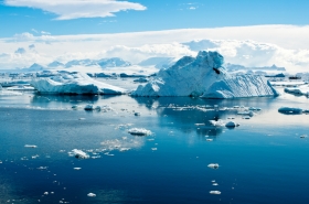
Described as being the coldest, driest, and windiest continent, it's no wonder why there are so many unknown mysteries of Antarctica. But now, for the first time scientists have begun mapping one of the "last frontiers" of the continent. The area, called the Recovery Catchment, sits around 400 km inland from the British Antarctic Survey's Halley VI Research Station in northeast Antarctica. It is important because it the vast area contains enough ice to raise sea-levels by up to 3 meters and the bedrock on which it sits is poorly understood. Another important aspect is that the rock hidden by the ice could hold the key to understanding how Antarctica was formed from the break-up of the supercontinents hundreds of millions of years ago.
Described as being the coldest, driest, and windiest continent, it's no wonder why there are so many unknown mysteries of Antarctica. But now, for the first time scientists have begun mapping one of the "last frontiers" of the continent.
!ADVERTISEMENT!
The area, called the Recovery Catchment, sits around 400 km inland from the British Antarctic Survey's Halley VI Research Station in northeast Antarctica.
It is important because it the vast area contains enough ice to raise sea-levels by up to 3 meters and the bedrock on which it sits is poorly understood.
Another important aspect is that the rock hidden by the ice could hold the key to understanding how Antarctica was formed from the break-up of the supercontinents hundreds of millions of years ago.
Dr Fausto Ferraccioli of the British Antarctic Survey (BAS), one of the researchers of the project called ICEGRAV, says, "For us this part of East Antarctica is one of the last frontiers and that is very exciting for science. When we explore at the very edge of our knowledge it can lead to huge shifts in our understanding."
"We need to understand the underlying topography as this will affect how the area responds to warming oceans."
"If the bedrock dips inland, away from where the ice sheet meets the sea, it could cause warm water to enter the system and create something called marine ice-sheet instability. If that happens then there's nothing to stop the ice sheet from retreating."
The ICEGRAV project is a major international collaboration between the UK, Denmark, Norway and Argentina which aims to explore the Recovery Catchment to understand how vulnerable it is to changes in the surrounding ocean and climate.
The scientists also hope to understand whether there are large lakes beneath the area, similar to Lake Ellsworth in West Antarctica.
These lakes, known as the Recovery Lakes, could be the largest in Antarctica.
The preliminary findings will be presented at the annual American Geophysical Union Fall Meeting by Ferraccioli and colleagues from the Danish National Space Institute and the Norwegian Polar Institute.
Read more at the British Antarctic Survey.
Sea ice image via Shutterstock.


