
A heads-up to New York, Baltimore, Houston and Miami: a new study suggests that these metropolitan areas and others will increase their exposure to floods even in the absence of climate change, according to researchers from Texas A&M University. The study presents first-ever global forecasts of how the exposure of urban land to floods and droughts may change due to urban expansion in the near future. In 2000, about 30 percent of the global urban land (over 75,000 square miles) was located in the high-frequency flood zones; by 2030, this will reach nearly 40 percent (280,000 square miles) as the global urban land grows from 250,000 square miles to 720,000 square miles, the authors say.
A heads-up to New York, Baltimore, Houston and Miami: a new study suggests that these metropolitan areas and others will increase their exposure to floods even in the absence of climate change, according to researchers from Texas A&M University.
Their work is published in Global Environmental Change.
The study presents first-ever global forecasts of how the exposure of urban land to floods and droughts may change due to urban expansion in the near future. In 2000, about 30 percent of the global urban land (over 75,000 square miles) was located in the high-frequency flood zones; by 2030, this will reach nearly 40 percent (280,000 square miles) as the global urban land grows from 250,000 square miles to 720,000 square miles, the authors say.
The researchers also predict that by 2030 the urban extent in drylands will nearly double, reaching over 190,000 square miles, and that even without climate change, extent of urban areas exposed to both floods and droughts would more than triple by 2030, according to the study.
“Urban areas exposed to flood and drought hazards will increase considerably due to the sheer increase in their extents driven primarily by socio-economic forces,” says Burak Güneralp, lead author of the study and a research assistant professor in geography at Texas A&M.
“In particular, coastal megacities will house a majority of the urban populations and they will increasingly be hubs of significant economic activity in the coming decades. Yet, potential future changes in the extent and layout of the urban areas are typically ignored in resilience planning for these cities.”
The study points to significant variation in the geographical patterns of how the exposure of cities, especially to flood hazards, will change in the first three decades of the 21st century. The largest increases in urban exposure are expected in high-frequency flood zones and arid lands of Asia and Africa. In particular, emerging coastal metropolitan regions in these two continents are expected to have larger areas exposed to flooding than those in developed countries.
Although relatively small compared to what we can expect in Asia and Africa, in the U.S. the expansion of Houston and Miami metropolitan areas as well as the metropolitan area between Baltimore and New York is expected to increase their exposure to flooding. In addition, the expansion of many urban areas in the Southwest U.S., in particular central and southern California, is expected to increase their exposure to drought.
The researchers used existing urban land cover maps and urban expansion forecasts and employed GIS analysis to identify the amount of urban expansion in flood and drought prone zones around the world in 2000 and 2030.
Continue reading at Texas A&M University.
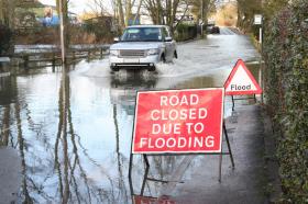
Flood image via Shutterstock.


