
Record flooding along some tributaries after torrential post-Christmas weekend rain has sent the Mississippi River to levels not seen since the Great Flood of 1993, and that excess water will continue to flow downstream triggering flooding in the Lower Mississippi Valley into mid-late January.
In the past week or so, nearly a dozen locations have seen water levels on rivers or creeks rise to new record crests, including on parts of the Mississippi River and the Meramec River. You can find a full recap of the records set near the bottom of this article.
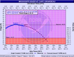
At Cape Girardeau, Missouri, about 115 miles south-southeast of St. Louis, the Mississippi River on Friday rose above the previous record flood crest there from the Great Flood of 1993, with a broad crest exceeding that of the August 8, 1993 crest. Water levels are now receding there and will continue to do so very slowly the next couple of days.
Fortunately, the city's downtown flood wall and levees protect Cape Girardeau to a river stage of 53 to 54 feet, significantly higher than what has been reached.
However, at least 25 homes are either flooded, or inaccessible due to the flooding, according to the city of Cape Girardeau's blog. The rising river prompted closures of numerous roads and intersections within the city earlier last week.
South of Cape Girardeau, the Mississippi River has already set a record at Thebes, Illinois, by nearly 2 feet. The river level there is forecast to stay at record level into early this week before gradually subsiding.
With this stretch of the river expected to remain in major flood into much of the week ahead, well after the crest, concern is high about the stressed levee system. For this reason, a flash flood watch has been issued by the National Weather Service for parts of southern Illinois, including Alexander, Jackson and Union Counties.
Flood stage at Cape Girardau credit National Weather Service.
Read more at the Weather Channel.


