
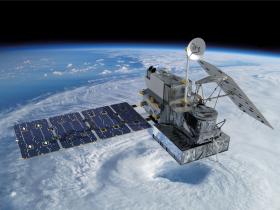
The Global Precipitation Measurement mission known as GPM passed over Tropical Depression Bonnie and found heavy rainfall from a few thunderstorms within.
Tropical Storm Bonnie weakened to a tropical depression on May 29, 2016. The circulation was labeled as "post-tropical" and has been moving very slowly to the northeast near the Carolinas coastline. Bonnie developed organized convection near the center and on June 2, 2016 the system was again labeled a tropical depression.
The GPM Core Observatory satellite saw Tropical Depression Bonnie on June 1, 2016, at 6:26 p.m. EDT (22:26 UTC). GPM's Microwave Imager (GMI) and Dual-Frequency Precipitation Radar (DPR) instruments measured precipitation in a few powerful convective thunderstorms falling at a rate of almost 4.9 inches (124 mm) per hour. Storm top heights of more than 9.3 miles (15 km) were found by GPM's Radar (Ku Band). GPM is a joint mission between NASA and the Japan Aerospace Exploration Agency (JAXA).
GPM satellite image via NASA's Goddard Space Flight Center
Read more at EurekAlert!


