
NASA's Aqua satellite passed over tropical cyclone Kay as it was designated a depression in the Eastern Pacific and identified areas of strong convection. That strong uplift of air continued to generate more powerful storms in the system and on Aug. 19 it strengthened into a tropical storm.
The Atmospheric Infrared Sounder or AIRS instrument that flies aboard NASA's Aqua satellite analyzed Kay as it was classified as a depression on Aug. 18 at 4:53 p.m. EDT (2053 UTC).
AIRS looked at Tropical Depression Kay in infrared light, gathering temperature data of the system's clouds. Coldest cloud top temperatures appeared south of the center at that time where some temperatures of the strongest storms exceeded minus 63 degrees Fahrenheit (minus 53 degrees Celsius). Storms with temperatures that cold are high in the troposphere and NASA research has shown they have the ability to generate heavy rain.
Continue reading at EurekAlert!
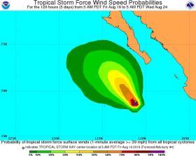
Graphics show probabilities of sustained (1-minute average) surface wind speeds equal to or exceeding 34 kt (39 mph)
Credits: National Hurricane Center / NOAA


