
A regional team from Woods Hole Oceanographic Institution (WHOI), Rutgers University, the University of Maine, the University of Maryland, and the Gulf of Maine Research Institute mobilized Friday in advance of post-Tropical Storm Hermine’s arrival in the Northeast to gather data from new ocean instruments that will help better predict the intensity and evolution of future tropical storms along the US East Coast.
The team, part of the TEMPESTS program organized through the Cooperative Institute for the North Atlantic Region, is funded by the NOAA office of Oceanic and Atmospheric Research.
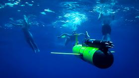
Operating from a boat in the waters south of Martha’s Vineyard, WHOI engineers Sean Whelan and Patrick Deane deployed an underwater glider – an ocean robot carrying sensors that can collect data and transmit it by satellite to scientists on shore. The glider will fly underwater across the continental shelf south of New England, in water approximately 100 – 300 feet deep. The glider is capable of sustaining itself at sea for about one month. Rutgers University has also launched two gliders across the New Jersey continental shelf. In addition to the gliders, buoys built by the University of Maine are also in place off-shore in Maine, Massachusetts and Maryland. The TEMPESTS program has also deployed ALAMO instruments from Hurricane Hunter aircraft to provide ocean temperature information farther off-shore and closer to the storm.
- See more at: http://www.whoi.edu/news-release/hermine-glider#sthash.JCHIXqqZ.dpuf
Image Credits: Sean Whelan / Woods Hole Oceanographic Institution


