
Today, more than 16 years of space-weather data is publicly available for the first time in history. The data comes from space-weather sensors developed by Los Alamos National Laboratory on board the nation’s Global Positioning System (GPS) satellites. The newly available data gives researchers a treasure trove of measurements they can use to better understand how space weather works and how best to protect critical infrastructure, such as the nation’s satellites, aircraft, communications networks, navigation systems, and electric power grid.
Today, more than 16 years of space-weather data is publicly available for the first time in history. The data comes from space-weather sensors developed by Los Alamos National Laboratory on board the nation’s Global Positioning System (GPS) satellites. The newly available data gives researchers a treasure trove of measurements they can use to better understand how space weather works and how best to protect critical infrastructure, such as the nation’s satellites, aircraft, communications networks, navigation systems, and electric power grid.
“Space-weather monitoring instruments developed at Los Alamos have been fielded on GPS satellites for decades,” said Marc Kippen, the Los Alamos program manager. “Today, 23 of the nation’s more than 30 on-orbit GPS satellites carry these instruments. When you multiply the number of satellites collecting data with the number of years they’ve been doing it, it totals more than 167 satellite years. It’s really an unprecedented amount of information.”
Extreme space-weather events have the potential to significantly threaten safety and property on Earth, in the air, and in space. For example, the hazard of increased radiation exposure from charged particles released during a large solar flare could require that flights be diverted away from a polar route. Similarly, sudden bursts of plasma and magnetic field structures (coronal mass ejections, or CMEs) from the sun’s atmosphere and high-speed solar wind could significantly disable large portions of the electric power grid. The resulting cascading failures could disturb air traffic control, disrupt the water supply, and interfere with life-saving medical devices.
Continue reading at DOE / Los Alamos National Laboratory
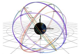
Illustration: An image illustrating the six orbital planes in which GPS satellites (“navigational satellites,” or ns) fly around Earth. This configuration shows the orbits just before the start of this solar cycle’s biggest geomagnetic storm, which occurred on March 17, 2015. The darkest orbital lines indicate the position of the satellites in that moment; the lightest lines indicate where they were 12 hours prior.
Illustration via Los Alamos National Laboratory


