
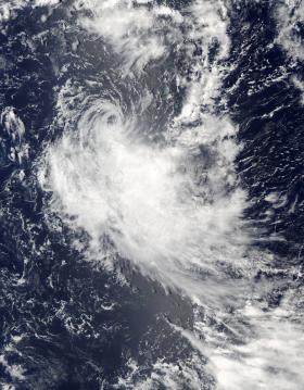
Tropical Cyclone 04S formed north of La Reunion Island on February 4 and continued to track slowly toward the island. This ended an unusual drought of tropical cyclone formation in that part of the Indian Ocean that began in July 2016. When NASA's Terra passed over the newly-formed tropical cyclone imagery showed a concentration of strong thunderstorms around the center of the compact storm. The storm was later renamed Tropical Cyclone Carlos.
Tropical Cyclone 04S formed north of La Reunion Island on February 4 and continued to track slowly toward the island. This ended an unusual drought of tropical cyclone formation in that part of the Indian Ocean that began in July 2016. When NASA's Terra passed over the newly-formed tropical cyclone imagery showed a concentration of strong thunderstorms around the center of the compact storm. The storm was later renamed Tropical Cyclone Carlos.
NASA's Global Precipitation Measurement mission or GPM core observatory satellite flew above tropical storm Carlos on February 5, 2017 at 1056 UTC (5:56 a.m. EST) when Carlos had maximum sustained winds of about 45 knots (51.8 mph). GPM collected data that showed the intensity and structure of precipitation within Carlos. GPM's Dual-Frequency Precipitation Radar (DPR) measured rain falling at a rate of over 100 mm (3.9 inches) per hour in intense feeder bands converging into Carlos' northeastern side.
The 3-D vertical structure of tropical storm Carlos was examined by GPM's radar (DPR Ku Band). This inspection showed that some of the powerful storms around the tropical cyclone had storm tops reaching heights greater than 14 km (8.8 miles). Heavy showers in a few of these storms were bouncing radar reflectivity values of almost 49 dBZ values back to the GPM satellite. GPM is a joint mission between NASA and the Japan Aerospace Exploration Agency.
Read more at NASA
Image Credits: NASA Goddard MODIS Rapid Response Team


