
Less than a year after the first research flight kicked off NASA’s Oceans Melting Greenland campaign, data from the new program are providing a dramatic increase in knowledge of how Greenland’s ice sheet is melting from below. Two new research papers in the journal Oceanography, including one by UCI Earth system scientist Mathieu Morlighem, use OMG observations to document how meltwater and ocean currents are interacting along Greenland’s west coast and to improve seafloor maps used to predict future melting and sea level rise.
Less than a year after the first research flight kicked off NASA’s Oceans Melting Greenland campaign, data from the new program are providing a dramatic increase in knowledge of how Greenland’s ice sheet is melting from below. Two new research papers in the journal Oceanography, including one by UCI Earth system scientist Mathieu Morlighem, use OMG observations to document how meltwater and ocean currents are interacting along Greenland’s west coast and to improve seafloor maps used to predict future melting and sea level rise.
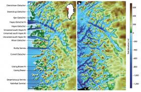
OMG is a five-year campaign to study the glaciers and ocean along Greenland’s 27,000-mile coastline. Its goal is to find out where and how fast seawater is melting the glacial ice. Most of the coastline and seafloor around the ice sheet had never been surveyed, so the 2016 flights expanded scientists’ knowledge of Greenland significantly. Future years of data collection will reveal the rate of change around the island.
The water circulating close around the Greenland Ice Sheet is like a cold river floating atop a warm, salty ocean. The top 600 feet (200 meters) of colder water is relatively fresh and comes from the Arctic. Below that is saltwater that comes from the south, 6 to 8 degrees Fahrenheit (3 to 4 degrees Celsius) warmer than the fresher water above. The layers don’t mix much because freshwater weighs less than saltwater, so it stays up top.
Read more at UCI
Image Credits: UCI


